IMAGES TAKEN NEAR TO
Hotwell Road, BRISTOL, BS8 4RP

Introduction

This page details the photographs taken nearby to Hotwell Road, BS8 4RP by members of the Geograph project.

The Geograph project started in 2005 with the aim of publishing, organising and preserving representative images for every square kilometre of Great Britain, Ireland and the Isle of Man.

There are currently over 7.5m images from over14,400 individuals and you can help contribute to the project by visiting https://www.geograph.org.uk

Image Map


Images are licensed for reuse under creativecommons.org/licenses/by-sa/2.0
Notes
  • Clicking on the map will re-center to the selected point.
  • The higher the marker number, the further away the image location is from the centre of the postcode.

Image Listing (1049 Images Found)

Images are licensed for reuse under creativecommons.org/licenses/by-sa/2.0
  • ...
Image
Details
Distance
1
View over the Avon to Hotwells and Clifton
Image: © Eirian Evans Taken: 1 Sep 2020
0.02 miles
2
Houses of Clifton Wood (3)
Image: © Anthony O'Neil Taken: 10 Apr 2021
0.03 miles
3
A profusion of ochre
Rosemont Terrace, Bristol
Image: © Anthony O'Neil Taken: 31 Jan 2023
0.03 miles
4
Poole's Wharf and Clifton Wood
From Baltic Wharf
Image: © Anthony O'Neil Taken: 10 Apr 2020
0.03 miles
5
Temple Meads to Ashton Gate (107)
Bus stop on the A4
Image: © Basher Eyre Taken: 13 Feb 2016
0.03 miles
6
Rooftops (2)
Clifton Wood, Bristol
Image: © Anthony O'Neil Taken: 20 Mar 2017
0.03 miles
7
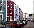
Cliftonwood - BS8
The view down Ambrose Road with the junction of Argyle Place behind the photographer.Visitors to any part of the strip of land sandwiched between the southern side of the Floating Harbour and the "New Cut" (i.e. the River Avon) inevitably find their eyes drawn upwards to the very dominant rows of brightly painted houses hugging the lower slopes of Cliftonwood like a multi-coloured knecklace. This picture of the front elevations of those "chocolate box-lid" houses lining Ambrose Road 'proves' that the colours don't simply appear on the rear elevations of each house - to impress tourists visiting the Floating Harbour area - but that the colours can equally surprise and impress observers seeing them from other perspectives too. Whether on dull days or bright sunny days these houses seem to radiate an clearly inferred joie de vivre.
Image: © David Hallam-Jones Taken: 1 Aug 2012
0.04 miles
8
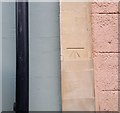
Ordnance Survey Cut Mark
This OS cut mark can be found on No28 Ambrose Road. It marks a point 36.049m above mean sea level.
Image: © Adrian Dust Taken: 3 Jan 2020
0.04 miles
9
Ambrose Road
The myriad colours of lower Clifton are a familiar part of the Bristol landscape around the old harbour. Looking at the less visible side of the houses shows the pastel shades are not just for show.
Image: © Neil Owen Taken: 13 Oct 2021
0.04 miles
10
Rainbow housing
Clifton Wood seen from Baltic Wharf
Image: © Anthony O'Neil Taken: 17 Apr 2021
0.05 miles
  • ...