IMAGES TAKEN NEAR TO
Alma Court, BRISTOL, BS8 2HH
Introduction
This page details the photographs taken nearby to Alma Court, BS8 2HH by members of the Geograph project.
The Geograph project started in 2005 with the aim of publishing, organising and preserving representative images for every square kilometre of Great Britain, Ireland and the Isle of Man.

There are currently over 7.5m images from over14,400 individuals and you can help contribute to the project by visiting https://www.geograph.org.uk
Image Map
Images are licensed for reuse under creativecommons.org/licenses/by-sa/2.0
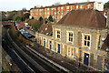
Notes
- Clicking on the map will re-center to the selected point.
- The higher the marker number, the further away the image location is from the centre of the postcode.
Image Listing (311 Images Found)
Images are licensed for reuse under creativecommons.org/licenses/by-sa/2.0
Image
Details
Distance
1
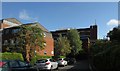
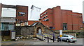
Alma Vale Road, Bristol
Approaching the rear of the Clifton Down shopping centre. On the left are flats at Alma Court.
Image: © Derek Harper
Taken: 9 Oct 2016
0.02 miles
2
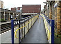
Ramp, Clifton Down railway station, Bristol
The ramp connects platform 1 with the footbridge to platform 2, and a side road leading to Whiteladies Road.
Image: © Jaggery
Taken: 7 May 2012
0.03 miles
3
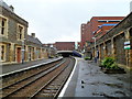
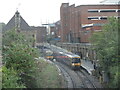
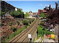
Clifton Down railway station, Bristol
A view east from platform 1. The station is located on the west side of Whiteladies Road, about 6 km (3¾ miles) west of Bristol Temple Meads. The next station ahead is Redland, on the route to Temple Meads. Behind the camera, the next station is Sea Mills, reached through a mile-long tunnel. http://www.geograph.org.uk/photo/1249068
Most trains from Temple Meads end at Avonmouth, with some going on to St Andrews Road and Severn Beach stations. The large building in the background on the right is a Sainsbury's supermarket in Clifton Down Shopping Centre.
Image: © Jaggery
Taken: 7 May 2012
0.03 miles
4
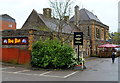
Roo Bar, Clifton Down railway station, Bristol
Located on the north side of Clifton Down railway station, set back from Whiteladies Road. The pub occupies part of the original station buildings, dating from 1874. And earlier pub occupying this location was named The Steam Tavern.
Image: © Jaggery
Taken: 7 May 2012
0.03 miles
5
An entrance to Clifton Down railway station, Bristol
This entrance, lined with dark blue railings, is on the north side of the station.
Image: © Jaggery
Taken: 7 May 2012
0.03 miles
6
Ready with the doors and a brolly
A commuter train arrives at Clifton Down station in a downpour.
Image: © Neil Owen
Taken: 2 Aug 2021
0.04 miles
7
The Roo Bar in Clifton Down
The Bar is in the former station building at Clifton Down.
Image: © Steve Daniels
Taken: 2 Jun 2011
0.04 miles
8
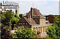
Clifton Down Station
The listed building as built in 1874 in the "Tudor Gothic Revival style" https://www.historicengland.org.uk/listing/the-list/list-entry/1202700 ". "Built as the terminus of the Clifton Extension Railway, it became a through station with the opening of the Clifton Down tunnel in 1885." Up on the left are the buildings shown in Image
Image: © Derek Harper
Taken: 9 Oct 2016
0.04 miles
9
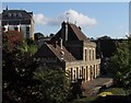
Clifton Down station
Seen from the car park at Clifton Down shopping centre. The terrace behind is on Whatley Road.
Image: © Derek Harper
Taken: 19 Feb 2019
0.04 miles
10
Clifton Down Station
A view from St John's Road.
Image: © Derek Harper
Taken: 13 May 2015
0.04 miles