IMAGES TAKEN NEAR TO
Alma Road Avenue, BRISTOL, BS8 2DH
Introduction
This page details the photographs taken nearby to Alma Road Avenue, BS8 2DH by members of the Geograph project.
The Geograph project started in 2005 with the aim of publishing, organising and preserving representative images for every square kilometre of Great Britain, Ireland and the Isle of Man.

There are currently over 7.5m images from over14,400 individuals and you can help contribute to the project by visiting https://www.geograph.org.uk
Image Map
Images are licensed for reuse under creativecommons.org/licenses/by-sa/2.0
Notes
- Clicking on the map will re-center to the selected point.
- The higher the marker number, the further away the image location is from the centre of the postcode.
Image Listing (354 Images Found)
Images are licensed for reuse under creativecommons.org/licenses/by-sa/2.0
Image
Details
Distance
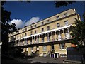
1
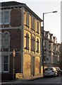
Alma Road, Bristol
The prominent building catching the late sun is shown from the other direction in Image
Image: © Derek Harper
Taken: 27 Oct 2017
0.04 miles
2
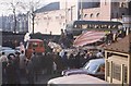
Medical Students 'Rag'
Bristol University 'RAG' Medical students decorated floats pass through congested area near university in 1963. The Cinema is showing Mutiny on the Bounty starring Marlon Brando.
Image: © Clive Warneford
Taken: Unknown
0.04 miles
3
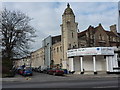
Whiteladies Picture House
On Whiteladies Road, Clifton, Bristol
Image: © Peter Barr
Taken: 11 Feb 2010
0.04 miles
4
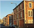
Alma Road, Bristol
Houses catching the evening sunlight; with the junctions with Alma Road Avenue and Sunningdale on the south side of the road.
Image: © Derek Harper
Taken: 27 Oct 2017
0.04 miles
5
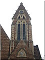
A saddleback tower
The former Unitarian church on Oakfield Road was designed by Pope and Bindon, who were popular architects in the area. Using a cusped decorated style, the church was built from Clifton ragstone extracted from nearby Durdham Down quarry. It features a large saddleback tower seen here.
Image: © Neil Owen
Taken: 2 Aug 2021
0.06 miles
6
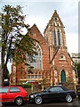
Oakfield Court, Clifton, Bristol
Viewed across Oakfield Road. Built in 1864 as Oakfield Road Unitarian Church.
The church closed in the 1980s. The building has been converted to offices.
Image: © Jaggery
Taken: 7 May 2012
0.07 miles
7
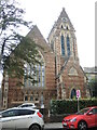
Oakfield Road church
The church was founded in 1864 to provide more local meetings for the Unitarian movement, saving them a trip to Lewins Mead in the centre of town. It was designed by Pope and Bindon and cost £6,000. The course of its service ended in February, 1989 and was sold off, with the intention of demolition and construction of residential units. However, a protest proved strong enough; the building was retained and converted into offices.
Image: © Neil Owen
Taken: 2 Aug 2021
0.07 miles
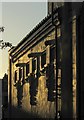
8
Terrace on Alma Road, Bristol
The low evening sun shines along this terrace, with Whiteladies Road at the end.
Image: © Derek Harper
Taken: 27 Oct 2017
0.07 miles
9
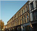
South Parade, Bristol
A listed terrace on Oakfield Road dating from about 1840 http://www.imagesofengland.org.uk/Details/Default.aspx?id=380038&mode=adv .
Image: © Derek Harper
Taken: 8 Sep 2013
0.08 miles
10
Whiteladies Picture House
The wall facing Melrose Place. "The auditorium wall is enlivened by symmetrical pylons of giant sunken panels and three winged wreaths supporting sunken panels with lattice decoration separated by triglyphs surmounted by double scrolls under a moulded cornice" https://www.historicengland.org.uk/listing/the-list/list-entry/1245430 .
Image: © Derek Harper
Taken: 27 Oct 2017
0.08 miles