IMAGES TAKEN NEAR TO
St. Pauls Road, BRISTOL, BS8 1LX
Introduction
This page details the photographs taken nearby to St. Pauls Road, BS8 1LX by members of the Geograph project.
The Geograph project started in 2005 with the aim of publishing, organising and preserving representative images for every square kilometre of Great Britain, Ireland and the Isle of Man.

There are currently over 7.5m images from over14,400 individuals and you can help contribute to the project by visiting https://www.geograph.org.uk
Image Map
Images are licensed for reuse under creativecommons.org/licenses/by-sa/2.0
Notes
- Clicking on the map will re-center to the selected point.
- The higher the marker number, the further away the image location is from the centre of the postcode.
Image Listing (343 Images Found)
Images are licensed for reuse under creativecommons.org/licenses/by-sa/2.0
Image
Details
Distance
1
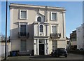
Building on St Paul's Road, Bristol
This is the end terrace of Image], a photo taken a few hours earlier when this façade was in shadow. It is described at http://list.historicengland.org.uk/resultsingle.aspx?uid=1202608&searchtype=mapsearch thus "A symmetrical 3-window right-hand return has a banded ground floor, semicircular-arched recess covered by a late C19 two-storey porch with Tuscan columns, glazed sides and C20 door, dentil cornice, clasping pilasters above to a bracketed cornice with a segmental arch and semicircular panel. Semicircular-arched stair window above".
Image: © Derek Harper
Taken: 22 Mar 2015
0.01 miles
2
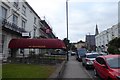
The Washington Guesthouse
Looking along St. Paul's Road in Bristol with a large guesthouse on the left.
Image: © DS Pugh
Taken: 25 Jun 2017
0.01 miles
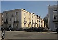
3
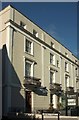
Regency Bristol Hotel, Victoria Park
Forming half of a listed terrace of six on St Paul's Road. "c1850. By Thomas Pennington" https://www.historicengland.org.uk/listing/the-list/list-entry/1207635 .
Image: © Derek Harper
Taken: 27 Oct 2017
0.03 miles
4
Tavistock Place, St Paul's Road
Tavistock Place refers to the terrace of houses on this section of St Paul's Road, but appears to be no longer in use as a postal address.
Image: © Alan Murray-Rust
Taken: 25 Jun 2017
0.03 miles
5
Sunderland Place, Bristol
The first four in the terrace are listed http://list.historicengland.org.uk/resultsingle.aspx?uid=1202608&searchtype=mapsearch . Seen across St Paul's Road from Oakfield Place.
Image: © Derek Harper
Taken: 22 Mar 2015
0.04 miles
6
Rears of terraces, Victoria Park
The rears of houses on Oakfield Place (right) and St Paul's Road, seen from the former. The spire belongs to St Paul's church http://list.english-heritage.org.uk/resultsingle.aspx?uid=1207682&searchtype=mapsearch , also visible in Image
Image: © Derek Harper
Taken: 23 Feb 2014
0.04 miles
7
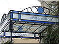
Caffe Clifton
A canopy on St Paul's Road evoking an earlier time.
Image: © Neil Owen
Taken: 1 Jul 2021
0.04 miles
8
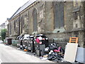
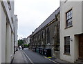
Rubbish outside St Paul's
There must have been some clear-out. Is it all from the church?
Image: © Neil Owen
Taken: 1 Jul 2021
0.04 miles
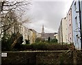
9
Oakfield Grove, Clifton
Narrow street alongside St Paul’s Church.
There is a bench mark http://www.geograph.org.uk/photo/5439882 on the nearest buttress of the church.
Image: © Alan Murray-Rust
Taken: 24 Jun 2017
0.04 miles
10
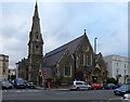
Church of St Paul, Clifton
Built 1853 by Manners and Gill, but substantially modified in 1867 by Hanson when the roofs of nave and aisles were raised, and different tracery was used for the windows. Listed Grade II.
Image: © Alan Murray-Rust
Taken: 24 Jun 2017
0.04 miles