IMAGES TAKEN NEAR TO
Orpen Gardens, BRISTOL, BS7 9UA
Introduction
This page details the photographs taken nearby to Orpen Gardens, BS7 9UA by members of the Geograph project.
The Geograph project started in 2005 with the aim of publishing, organising and preserving representative images for every square kilometre of Great Britain, Ireland and the Isle of Man.

There are currently over 7.5m images from over14,400 individuals and you can help contribute to the project by visiting https://www.geograph.org.uk
Image Map
Images are licensed for reuse under creativecommons.org/licenses/by-sa/2.0
Notes
- Clicking on the map will re-center to the selected point.
- The higher the marker number, the further away the image location is from the centre of the postcode.
Image Listing (38 Images Found)
Images are licensed for reuse under creativecommons.org/licenses/by-sa/2.0
Image
Details
Distance
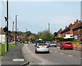
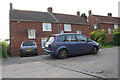
1
Orpen Gardens, Bristol
Viewed from the corner of Romney Avenue.
Image: © Jaggery
Taken: 29 Dec 2013
0.03 miles
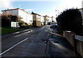
2
2011 : Romney Avenue, Bristol
Heading north east toward Lockleaze.
The round black thing near the left hand edge lights up when errant drivers exceed the 30 mph speed limit. Saw it light up once while there, waited in vain for a picture. They are all good people in Lockleaze.
Image: © Maurice Pullin
Taken: 17 Apr 2011
0.08 miles
3
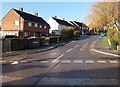
Brangwyn Grove, Bristol
Viewed across Romney Avenue.
Image: © Jaggery
Taken: 29 Dec 2013
0.10 miles
4
Too warm to be on the roof
Council houses in Lockleaze are being repaired, despite the sunny weather. The Memorial Stadium is in the background.
Image: © Neil Owen
Taken: 13 May 2016
0.11 miles
5
Car parked outside Brangwyn Grove houses
There is an OS benchmark Image on the left hand side of the left hand house near its back corner
Image: © Roger Templeman
Taken: 3 May 2014
0.11 miles
6
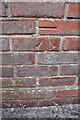
Benchmark on #17 Brangwyn Grove
Ordnance Survey cut mark benchmark described on the Bench Mark Database at http://www.bench-marks.org.uk/bm57121
Image: © Roger Templeman
Taken: 3 May 2014
0.11 miles
7
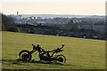
Lockleaze Open Space
Once marked out with white lines and sporting goalposts fit for Saturday League football, this council-owned land never was the proverbial "level playing field". It now hosts rather different recreational pursuits.
Image: © Martin
Taken: 21 Mar 2007
0.11 miles
8
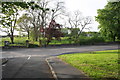
Junction of Haydon Gardens with Romney Avenue
On the far side of Romney Avenue is the site of Romney Avenue School, now demolished.
Image: © Roger Templeman
Taken: 3 May 2014
0.12 miles
9
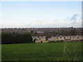
Houses in Orpen Gdns backing onto playing fields at Pur Down
Image: © Dr Duncan Pepper
Taken: 26 Oct 2008
0.12 miles
10
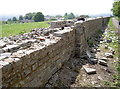
A new wall for Sir John
The old Heath House estate was a significant part of the landscape in years gone by, owned by the Smyth family. They had this wall built along the lane in the 1780s. This part of the wall runs for nearly 350m and used to stand at 3m high. Sadly, neglect and change of ownership has brought about the need to repair large sections of it. Specialist masons have been brought in to rebuild it in period, using lime mortar, as befits a Grade II structure.
Image: © Neil Owen
Taken: 13 May 2016
0.13 miles