IMAGES TAKEN NEAR TO
Fairacre Close, BRISTOL, BS7 9TW
Introduction
This page details the photographs taken nearby to Fairacre Close, BS7 9TW by members of the Geograph project.
The Geograph project started in 2005 with the aim of publishing, organising and preserving representative images for every square kilometre of Great Britain, Ireland and the Isle of Man.

There are currently over 7.5m images from over14,400 individuals and you can help contribute to the project by visiting https://www.geograph.org.uk
Image Map
Images are licensed for reuse under creativecommons.org/licenses/by-sa/2.0
Notes
- Clicking on the map will re-center to the selected point.
- The higher the marker number, the further away the image location is from the centre of the postcode.
Image Listing (54 Images Found)
Images are licensed for reuse under creativecommons.org/licenses/by-sa/2.0
Image
Details
Distance
1
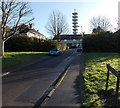
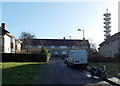
Gilray Close, Bristol
Gilray Close is a 70 metre long cul-de-sac on the SE side of Romney Avenue.
Visible from a wide area, a telecommunications tower on Pur Down is in the background.
Image: © Jaggery
Taken: 29 Dec 2013
0.03 miles
2
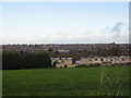
Houses in Orpen Gdns backing onto playing fields at Pur Down
Image: © Dr Duncan Pepper
Taken: 26 Oct 2008
0.05 miles
3
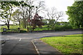
Junction of Haydon Gardens with Romney Avenue
On the far side of Romney Avenue is the site of Romney Avenue School, now demolished.
Image: © Roger Templeman
Taken: 3 May 2014
0.08 miles
4
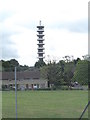
Pur Down Communications Tower
Seen from Stoke Park Primary School
Image: © Eirian Evans
Taken: 1 Aug 2014
0.08 miles
5
Rackham Close, Bristol
Rackham Close is a 70 metre long cul-de-sac on the SE side of Romney Avenue.
Visible from a wide area, a communications tower on Pur Down is in the background.
Image: © Jaggery
Taken: 29 Dec 2013
0.09 miles
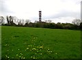
6
Communications tower viewed from Haydon Gardens, Bristol
Visible from a wide area, the tower is on Pur Down, about 200 metres from the camera.
Image: © Jaggery
Taken: 29 Dec 2013
0.09 miles
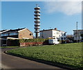
7
BTmicrowave telecommunication tower on Pur Down
A prominent object visible from the M32, is sited on an old WW2 anti-aircraft gun site.
Image: © Dr Duncan Pepper
Taken: 26 Oct 2008
0.10 miles
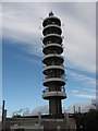
8
Purdown BT Tower
Telecommunications tower, built in 1970 and located on a hill (Purdown) just north of the city centre of Bristol, in the Lockleaze suburb. It is a prominent landmark, visible from much of the city, which forms part of the British Telecom microwave network.
Image: © Eirian Evans
Taken: 20 Apr 2017
0.10 miles
9
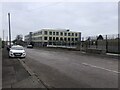
Trinity Academy, Stapleton
New building opened in 2021 for the school. This houses a Concert Hall, Sports Hall, Dance Studio, Drama Studio, Library as well as classrooms
Image: © Eirian Evans
Taken: 21 Jan 2022
0.10 miles
10
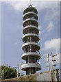
Eight platforms
The old telecommunications tower was built in 1970 to provide microwave services to broadcasters and other customers. The technology then used to depend on 'line of sight' access to other towers and stations, and therefore was obstructed by poor atmospheric conditions sometimes. These days the systems have mainly been succeeded by better methods. Once the eight platforms were festooned with all manner of aerials and dishes, but today they are noticeably less decorated.
Image: © Neil Owen
Taken: 13 May 2016
0.10 miles