IMAGES TAKEN NEAR TO
Dirac Road, BRISTOL, BS7 9LP
Introduction
This page details the photographs taken nearby to Dirac Road, BS7 9LP by members of the Geograph project.
The Geograph project started in 2005 with the aim of publishing, organising and preserving representative images for every square kilometre of Great Britain, Ireland and the Isle of Man.

There are currently over 7.5m images from over14,400 individuals and you can help contribute to the project by visiting https://www.geograph.org.uk
Image Map (Loading...)


Getting Data...Please wait
Leaflet Map data © OpenStreetMap
Images are licensed for reuse under creativecommons.org/licenses/by-sa/2.0
Notes
- Clicking on the map will re-center to the selected point.
- The higher the marker number, the further away the image location is from the centre of the postcode.
Image Listing (97 Images Found)
Images are licensed for reuse under creativecommons.org/licenses/by-sa/2.0
Image
Details
Distance
1
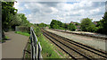
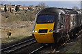
Railway line at Boiling Wells
The main line northwards from Bristol, seen from footpath BCC 209/10.
Image: © Derek Harper
Taken: 7 May 2019
0.03 miles
2
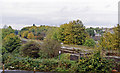
Site of Ashley Hill station
View SW, over the ex-GWR main line - formerly four-track, Bristol (right) - (left) Filton Junction, the Severn Tunnel and South Wales, Birmingham via Cheltenham and Swindon and London via Badminton. The station was closed on 23/11/64 (goods 1/11/66) and the route was reduced to double-track in the 1960s but has since been the only line up from Temple Meads to Bristol Parkway and everywhere.
Image: © Ben Brooksbank
Taken: 24 Oct 1992
0.05 miles
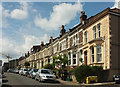
3
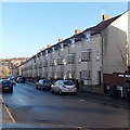
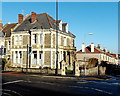
Lydia Court, Station Road, Bristol
Houses in the Ashley Down area of Bristol.
Image: © Jaggery
Taken: 29 Dec 2013
0.06 miles
4
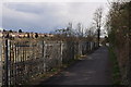
Bristol : Footpath
A footpath heading through the Bristol area.
Image: © Lewis Clarke
Taken: 24 Mar 2015
0.06 miles
5
Bristol : Railway Track
A Cross Country train heading along the railway line here through Bristol.
Image: © Lewis Clarke
Taken: 24 Mar 2015
0.06 miles
6
Station Road, Ashley Down
A terrace of 18 seen from the junction with Ashgrove Road.
Image: © Derek Harper
Taken: 7 May 2019
0.06 miles
7
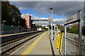
Ashley Down railway station, Bristol
Opened in 1864 as "Ashley Hill" by the Bristol and South Wales Union Railway, later part of the Great Western Railway, on what is now the line from Bristol Temple Meads towards the Severn Tunnel, Bristol Parkway etc. This station was expanded to four platforms in 1933 but closed in 1964 and was demolished. It was rebuilt and reopened with two platforms as "Ashley Down" in 2024 by Network Rail.
View north towards Horfield, Filton Abbey Wood and Bristol Parkway. The two lines on the far right were removed in 1984 but reinstated in 2018.
Image: © Nigel Thompson
Taken: 27 Oct 2024
0.07 miles
8
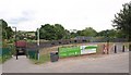
Northern cycling route, Bristol
In 2008, Greater Bristol was chosen as England's first official Cycling City, and this is part of a recently-completed section of a major cycling route into the centre of the city from the northern suburbs. It is also the site of Ashley Hill Station, which closed in 1964 after almost exactly 100 years of use. The path on the left crosses under the railway line to Station Lane and Muller Road. Seen from Station Road.
Image: © Derek Harper
Taken: 10 Jul 2009
0.07 miles
9
Bristol : City Scenery
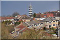
Looking across the rooftops of the Bristol suburbs.
Image: © Lewis Clarke
Taken: 24 Mar 2015
0.07 miles
10
Corner of Ashley Down Road and Station Road, Bristol
In the Ashley Down area of Bristol.
Image: © Jaggery
Taken: 29 Dec 2013
0.07 miles