IMAGES TAKEN NEAR TO
Pople Walk, BRISTOL, BS7 9DB
Introduction
This page details the photographs taken nearby to Pople Walk, BS7 9DB by members of the Geograph project.
The Geograph project started in 2005 with the aim of publishing, organising and preserving representative images for every square kilometre of Great Britain, Ireland and the Isle of Man.

There are currently over 7.5m images from over14,400 individuals and you can help contribute to the project by visiting https://www.geograph.org.uk
Image Map
Images are licensed for reuse under creativecommons.org/licenses/by-sa/2.0
Notes
- Clicking on the map will re-center to the selected point.
- The higher the marker number, the further away the image location is from the centre of the postcode.
Image Listing (112 Images Found)
Images are licensed for reuse under creativecommons.org/licenses/by-sa/2.0
Image
Details
Distance
1

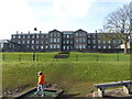
A view across hillside allotments to Muller House off Ashley Down Road, Bristol
The view from a stationary Bristol-bound train. The tower appears top centre in Derek Harper's Image
Image: © Robin Stott
Taken: 24 Jun 2017
0.02 miles
2
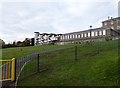
Muller House
Built as an orphanage by George Muller in the 1840s. George Muller, born in Prussia, came to Bristol in 1832 as a pastor in a local church. He decided to build orphanages after a bad cholera epidemic in Bristol and over the years cared for 10,000+ orphaned children. After its closure in 1958, Muller House became part of Bristol College of Science & Technology. Latterly the buildings were empty, until conversion to apartments.
Image: © Eirian Evans
Taken: 27 Oct 2016
0.02 miles
3
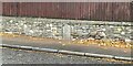
Old Boundary Marker on Ashley Down Road, Bristol
Municipal Boundary set in a stone wall on the west side of the B4052 Ashley Down Road, Bristol. On the former boundary of the City of Bristol and Stapleton parish but since 1898 entirely within the city.
Milestone Society National ID: GL_BRIS20pb
Image: © S Kosciow
Taken: 27 Nov 2021
0.02 miles
4

Postbox, Ashley Down Road
George V postbox BS7 7D is by the bus shelter opposite City of Bristol College's Ashley Down Centre.
Image: © Derek Harper
Taken: 7 May 2019
0.04 miles
5
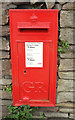
Postbox, Ashley Down Road
Confirmation of identification of Image]: George V postbox BS7 7D, against the wall fronting Muller House.
Image: © Derek Harper
Taken: 7 May 2019
0.04 miles
6
Muller House, Ashley Down, Bristol
Built as an orphanage by George Muller in the 1840s. After closure in 1958, Muller House became part of Bristol College of Science & Technology. Latterly the buildings were empty, until conversion to apartments, as part of a large development in the area by Charles Church.
Image: © Jaggery
Taken: 29 Dec 2013
0.04 miles
7
Muller House
Built as an orphanage by George Muller in the 1840s. George Muller, born in Prussia, came to Bristol in 1832 as a pastor in a local church. He decided to build orphanages after a bad cholera epidemic in Bristol and over the years cared for 10,000+ orphaned children. After its closure in 1958, Muller House became part of Bristol College of Science & Technology. Latterly the buildings were empty, until conversion to apartments.
Image: © Eirian Evans
Taken: 16 Feb 2018
0.05 miles
8
Pollarded trees, Sefton Park Road
Pollarding is a pruning system involving the removal of the upper branches of a tree, to promote a dense head of foliage and branches. The practice has occurred commonly in Europe since medieval times and takes place today in urban areas to maintain trees at a predetermined height.
Image: © Eirian Evans
Taken: 21 Feb 2018
0.06 miles
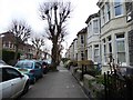
9
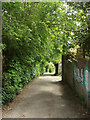
Stoney Lane
Footpath BCC 205/30 follows this lane from Ashley Down Road down into Ashley Vale. There's vehicle access to a back alley just ahead on the right, serving houses on the main road and Kathdene Gardens.
Image: © Derek Harper
Taken: 7 May 2019
0.07 miles
10
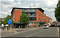
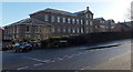
Ashley Heights
The Co-op is on the ground floor of this end of the building shown in Image], seen across Ashley Down Road. The blue notice directs you to the City of Bristol College's Ashley Down Centre, just off to the left.
Image: © Derek Harper
Taken: 7 May 2019
0.07 miles