IMAGES TAKEN NEAR TO
Maple Road, BRISTOL, BS7 8RL
Introduction
This page details the photographs taken nearby to Maple Road, BS7 8RL by members of the Geograph project.
The Geograph project started in 2005 with the aim of publishing, organising and preserving representative images for every square kilometre of Great Britain, Ireland and the Isle of Man.

There are currently over 7.5m images from over14,400 individuals and you can help contribute to the project by visiting https://www.geograph.org.uk
Image Map
Images are licensed for reuse under creativecommons.org/licenses/by-sa/2.0
Notes
- Clicking on the map will re-center to the selected point.
- The higher the marker number, the further away the image location is from the centre of the postcode.
Image Listing (125 Images Found)
Images are licensed for reuse under creativecommons.org/licenses/by-sa/2.0
Image
Details
Distance
1
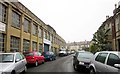
Elm Road Garage, Horfield
In an old works opposite terraced houses. At the end is the junction with Maple Road.
Image: © Derek Harper
Taken: 22 Apr 2014
0.04 miles
2
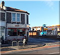
Zest in Horfield, Bristol
Zest is a Mediterranean cuisine cafe bar lounge at 408 Gloucester Road, on the corner of Church Road.
Image: © Jaggery
Taken: 29 Dec 2013
0.06 miles
3
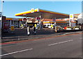
Gloucester Road Shell filling station, Bristol
The filling station, car wash and shop is on the corner of Gloucester Road and Church Road.
Image: © Jaggery
Taken: 29 Dec 2013
0.06 miles
4
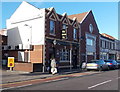
The Queen Vic, Bristol
The Gloucester Road pub was formerly named the Victoria Inn.
The yellow No Entry sign is at the exit from a Shell filling station. http://www.geograph.org.uk/photo/4015421
Image: © Jaggery
Taken: 29 Dec 2013
0.07 miles
5
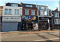
Floyds Barber Shop and Street Art Gallery, Horfield, Bristol
Floyds website states that "Our barbershop (at 390 Gloucester Road) provides a unique mix where you can check out Bristol’s latest street art, listen to some of Bristol's finest music and of course get quite possibly the sharpest haircut in the city!".
Also in view are Café Rhubarb on the left and Laroussi gallery on the right.
Image: © Jaggery
Taken: 29 Dec 2013
0.07 miles
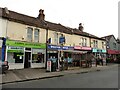
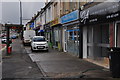
7
Gloucester Road, Horfield
Looking north along the A38 from the junction with Ashley Down Road. On the right is a soft play coffee lounge, followed by a hairdressers, a letting agency and an Indian curry house.
Image: © Derek Harper
Taken: 16 Nov 2015
0.08 miles
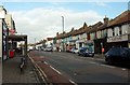
8
Bristol : Gloucester Road
A main road heading through Bristol.
Image: © Lewis Clarke
Taken: 24 Mar 2015
0.08 miles
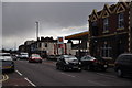
9
Bristol : Gloucester Road
The pavement alongside some shops and a bus stop on Gloucester Road.
Image: © Lewis Clarke
Taken: 24 Mar 2015
0.08 miles
10
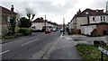
Church Road, Horfield, Bristol
Church Road descends away from Wellington Hill past the left turn for Churchways Avenue
Image: © Jaggery
Taken: 30 Jan 2013
0.09 miles