IMAGES TAKEN NEAR TO
Manor Court Drive, BRISTOL, BS7 0XF
Introduction
This page details the photographs taken nearby to Manor Court Drive, BS7 0XF by members of the Geograph project.
The Geograph project started in 2005 with the aim of publishing, organising and preserving representative images for every square kilometre of Great Britain, Ireland and the Isle of Man.

There are currently over 7.5m images from over14,400 individuals and you can help contribute to the project by visiting https://www.geograph.org.uk
Image Map
Images are licensed for reuse under creativecommons.org/licenses/by-sa/2.0
Notes
- Clicking on the map will re-center to the selected point.
- The higher the marker number, the further away the image location is from the centre of the postcode.
Image Listing (105 Images Found)
Images are licensed for reuse under creativecommons.org/licenses/by-sa/2.0
Image
Details
Distance
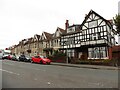
1
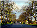
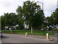
Kellaway Avenue, looking south-west
Looking along Kellaway Avenue from the junction with the Gloucester Road. These trees appear in a postcard taken in 1925 as newly planted saplings.
Looking out of the grid-square towards the south-west.
Image: © Linda Bailey
Taken: 1 Apr 2006
0.03 miles
2
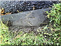
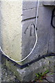
Benchmark on kerbstone of Kellaway Avenue
Ordnance Survey 1956 rivet benchmark which is described on the Bench Mark Database at http://www.bench-marks.org.uk/bm27966.
Image: © Roger Templeman
Taken: 14 Aug 2010
0.05 miles
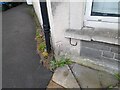
3
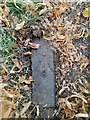
Ordnance Survey Rivet
This OS rivet can be found on a kerb stone NW side of Kellaway Avenue. It marks a point 83.451m above mean sea level.
Image: © Adrian Dust
Taken: 28 Jul 2022
0.05 miles
4
Green island at the junction of Gloucester Road and Kellaway Avenue
Image: © Eirian Evans
Taken: 22 Aug 2010
0.06 miles
5
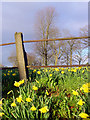
Daffodils on Horfield Common
Looking east, standing beside the Gloucester Road, there is a small bank at the edge of the common. Each year the daffodils appear, though they are about 2 weeks later than normal in appearing here.
Image: © Linda Bailey
Taken: 1 Apr 2006
0.06 miles
6
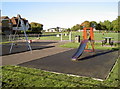
Children's play area
Horfield Common, Bristol. Just at the far end of the common (with its arched roof) is the sports centre, within whose bounds is a skateboard park for the slightly older children.
Image: © Neil Owen
Taken: 25 Sep 2010
0.07 miles
7
Benchmark on #573 Gloucester Road
Ordnance Survey cut mark benchmark described on the Bench Mark Database at http://www.bench-marks.org.uk/bm47500
Image: © Roger Templeman
Taken: 2 Mar 2013
0.07 miles
8
Ordnance Survey Cut Mark
This OS cut mark can be found on No573 Gloucester Road. It marks a point 82.537m above mean sea level.
Image: © Adrian Dust
Taken: 1 Jul 2022
0.07 miles
9
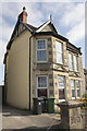
#573 Gloucester Road
There is an OS benchmark Image on the front corner of the house, left of the wheelie bins
Image: © Roger Templeman
Taken: 2 Mar 2013
0.08 miles