IMAGES TAKEN NEAR TO
Cranbrook Road, BRISTOL, BS6 7QX
Introduction
This page details the photographs taken nearby to Cranbrook Road, BS6 7QX by members of the Geograph project.
The Geograph project started in 2005 with the aim of publishing, organising and preserving representative images for every square kilometre of Great Britain, Ireland and the Isle of Man.

There are currently over 7.5m images from over14,400 individuals and you can help contribute to the project by visiting https://www.geograph.org.uk
Image Map
Images are licensed for reuse under creativecommons.org/licenses/by-sa/2.0
Notes
- Clicking on the map will re-center to the selected point.
- The higher the marker number, the further away the image location is from the centre of the postcode.
Image Listing (122 Images Found)
Images are licensed for reuse under creativecommons.org/licenses/by-sa/2.0
Image
Details
Distance
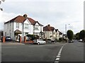
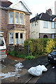
2
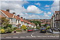
2 and 4 Linden Road
Pair of distinctive bungalows with verandahs, situated at the fork of Linden Road and Upper Cranbrook Road.
Image: © Ian Capper
Taken: 25 Jun 2017
0.05 miles
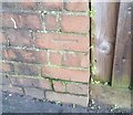
3
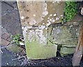
Ordnance Survey Cut Mark
This OS cut mark can be found on the wall at the bottom of Harcourt Hill. It marks a point 57.208m above mean sea level.
Image: © Adrian Dust
Taken: 20 Jan 2020
0.05 miles
4
Cranbrook Road
Taken at the point where Linden Road becomes Cranbrook Road, with Upper Cranbrook Road on the left.
Image: © Colin Bews
Taken: 31 May 2011
0.06 miles
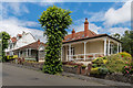
5
Harcourt Hill
Harcourt Hill is shown undeveloped on the 1903 6 inch map, but building doesn't appear to have taken place before the 1930s.
Image: © Ian Capper
Taken: 25 Jun 2017
0.06 miles
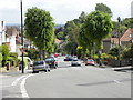
6
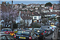
Bristol : Harcourt Hill
A road and the surrounding residential houses in Redland.
Image: © Lewis Clarke
Taken: 24 Mar 2015
0.07 miles
7
Ordnance Survey Cut Mark
This OS cut mark can be found on the wall north side of Harcourt Road. It marks a point 70.000m above mean sea level.
Image: © Adrian Dust
Taken: 20 Jan 2020
0.09 miles
8
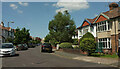
Harcourt Road, Westbury Park
A bend in the residential road.
Image: © Derek Harper
Taken: 17 Jul 2021
0.09 miles
9

Harcourt Road, Westbury Park
From the junction with Branksome Road.
Image: © Derek Harper
Taken: 17 Jul 2021
0.09 miles
10
Snow, Harcourt Road, Bristol
Evidence of a recent fall, and presumably the remains of a snowman, at the bend where Harcourt Road becomes Metford Road.
Image: © Derek Harper
Taken: 29 Dec 2017
0.09 miles