IMAGES TAKEN NEAR TO
Cranbrook Road, BRISTOL, BS6 7DD
Introduction
This page details the photographs taken nearby to Cranbrook Road, BS6 7DD by members of the Geograph project.
The Geograph project started in 2005 with the aim of publishing, organising and preserving representative images for every square kilometre of Great Britain, Ireland and the Isle of Man.

There are currently over 7.5m images from over14,400 individuals and you can help contribute to the project by visiting https://www.geograph.org.uk
Image Map
Images are licensed for reuse under creativecommons.org/licenses/by-sa/2.0
Notes
- Clicking on the map will re-center to the selected point.
- The higher the marker number, the further away the image location is from the centre of the postcode.
Image Listing (76 Images Found)
Images are licensed for reuse under creativecommons.org/licenses/by-sa/2.0
Image
Details
Distance
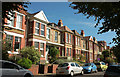
1
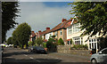
Cranbrook Road, Bristol
A little south of Clare Avenue.
Image: © Derek Harper
Taken: 26 Sep 2018
0.01 miles
2
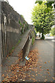
Ramp, Cranbrook Road, Bristol
A path climbs away from the pavement to reach houses perched above the west side of the road.
Image: © Derek Harper
Taken: 26 Sep 2018
0.02 miles
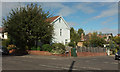
3
Clare Avenue
The road drops from the junction with Cranbrook Road to a junction with Claremont Avenue, and then climbs.
Image: © Derek Harper
Taken: 26 Sep 2018
0.04 miles
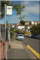
4
Junction on Cranbrook Road, Redland
Clare Avenue turns off to the right.
Image: © Derek Harper
Taken: 26 Sep 2018
0.04 miles
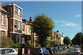
5
Houses on Claremont Avenue
Part of an impressive and longish terrace of 22 properties, I make it, on the northeastern side of the road.
Image: © Derek Harper
Taken: 26 Sep 2018
0.04 miles
6

Clare Avenue
Clare Avenue is shown undeveloped on the 1916 6 inch map, but building doesn't appear to have taken place before the 1930s.
Image: © Ian Capper
Taken: 25 Jun 2017
0.05 miles
7
Claremont Avenue. Bishopston
A little further southeast from Image]; still the same terrace.
Image: © Derek Harper
Taken: 26 Sep 2018
0.05 miles
8
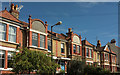
Facades, Claremont Avenue. Bishopston
Image: © Derek Harper
Taken: 26 Sep 2018
0.06 miles
9
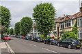
Cranbrook Road
Cranbrook Road is shown on the 1903 6 inch map, but except for the lower end, towards its junction with Gloucester Road, building doesn't appear to have taken place before the 1930s.
Image: © Ian Capper
Taken: 25 Jun 2017
0.07 miles
10
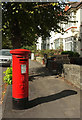
Postbox, Cranbrook Road
Another view of George V postbox BS6 339 Image], showing the cypher.
Image: © Derek Harper
Taken: 26 Sep 2018
0.07 miles