IMAGES TAKEN NEAR TO
Redland Road, BRISTOL, BS6 6YQ
Introduction
This page details the photographs taken nearby to Redland Road, BS6 6YQ by members of the Geograph project.
The Geograph project started in 2005 with the aim of publishing, organising and preserving representative images for every square kilometre of Great Britain, Ireland and the Isle of Man.

There are currently over 7.5m images from over14,400 individuals and you can help contribute to the project by visiting https://www.geograph.org.uk
Image Map
Images are licensed for reuse under creativecommons.org/licenses/by-sa/2.0
Notes
- Clicking on the map will re-center to the selected point.
- The higher the marker number, the further away the image location is from the centre of the postcode.
Image Listing (307 Images Found)
Images are licensed for reuse under creativecommons.org/licenses/by-sa/2.0
Image
Details
Distance
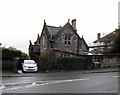
1
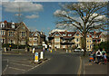
Junction, Redland
Redland Hill (foreground) meets Redland Road at this roundabout. The houses in the centre are by a further junction with Manor Park; the house seen above the bollards can be seen on the right of Image
Image: © Derek Harper
Taken: 15 Apr 2022
0.01 miles
2
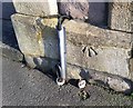
Ordnance Survey Cut Mark
This OS cut mark can be found on the gatepost of No169 Manor Park. It marks a point 85.280m above mean sea level.
Image: © Adrian Dust
Taken: 20 Jan 2020
0.01 miles
3
Manor Park, Bristol
From its eastern junction with Redland Road (it has two).
Image: © Derek Harper
Taken: 16 Oct 2016
0.02 miles
4
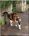
Cat in Redland #2
A friendly tortoiseshell on Manor Park.
Image: © Derek Harper
Taken: 2 Apr 2015
0.04 miles
5
Redland Road substation
An electricity substation in a small 'house' on Redland Road.
Image: © Neil Owen
Taken: 2 Aug 2021
0.04 miles
6
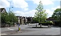
Roundabout on Redland Road
At the junction of Redland Road and Redland Hill. An area of relatively upmarket large terraced and detached houses dating from circa 1900.
Image: © Gordon Hatton
Taken: 24 May 2017
0.04 miles
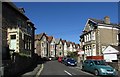
7

Terraced houses, Manor Park
Typical 'Bristol style' terraced houses in Manor Park with two storeys plus spacious attic rooms. Many such houses in this area were student 'digs' in the 1960's for those attending the nearby, but long since vanished Redland College for teacher training. This house has particular memories for the photographer, though even after a close examination, no trace could be seen of the small holes made for pitons when a friend made a climbing route up the front of the house.
Image: © Gordon Hatton
Taken: 24 May 2017
0.05 miles
8
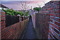
Bristol : Footpath
A footpath heading through the residential areas of Bristol.
Image: © Lewis Clarke
Taken: 24 Mar 2015
0.06 miles
9
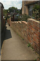
Footpath, Redland
Footpath BCC 184/30 seen from its junction with Redland Road. The path drops to Hazel Avenue and then to Elm Lane.
Image: © Derek Harper
Taken: 15 Apr 2022
0.06 miles
10
House on Redland Hill
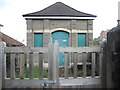
A distinctive stone house near the roundabout at the junction of Redland Road and Redland Hill
Image: © Eirian Evans
Taken: 15 Oct 2014
0.06 miles