IMAGES TAKEN NEAR TO
Herapath Street, BRISTOL, BS5 9SE
Introduction
This page details the photographs taken nearby to Herapath Street, BS5 9SE by members of the Geograph project.
The Geograph project started in 2005 with the aim of publishing, organising and preserving representative images for every square kilometre of Great Britain, Ireland and the Isle of Man.

There are currently over 7.5m images from over14,400 individuals and you can help contribute to the project by visiting https://www.geograph.org.uk
Image Map
Images are licensed for reuse under creativecommons.org/licenses/by-sa/2.0
Notes
- Clicking on the map will re-center to the selected point.
- The higher the marker number, the further away the image location is from the centre of the postcode.
Image Listing (96 Images Found)
Images are licensed for reuse under creativecommons.org/licenses/by-sa/2.0
Image
Details
Distance
1
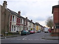
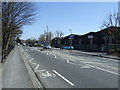
Glendare Street
This old residential road is in Barton Hill and runs from Marsh Lane next to the recreation ground to Great Western Lane. It contains a variety of terraced housing mainly from the late 19th C and early 20th C.
Image: © Nigel Mykura
Taken: 23 Feb 2013
0.05 miles
2
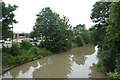
The Feeder
Looking along the Feeder canal linking the River Avon into the floating harbour.
Image: © DS Pugh
Taken: 27 Jun 2017
0.05 miles
3
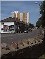
Marsh Lane, Barton Hill
The high rise beyond the terrace is Barton House. The left turn is Herapath Street. Seen from the edge of Netham Park, with wall in foreground.
Image: © Derek Harper
Taken: 13 Jul 2013
0.06 miles
5
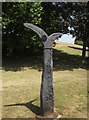
Fossil Tree milepost, Netham Park
This Millennium Milepost, an example of the Fossil Tree design by John Mills, can be seen in Image, and is on NCN3.
Image: © Derek Harper
Taken: 13 Jul 2013
0.07 miles
6
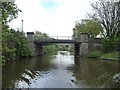
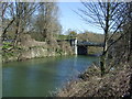
Barton Hill or Marsh Lane Bridge, from the west
Carrying Marsh Lane over Bristol's Feeder Canal.
Image: © Christine Johnstone
Taken: 3 May 2015
0.07 miles
9
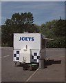
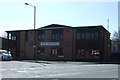
Joeys, Avonside Industrial Estate
I was on a mission to cover a lot of distance quickly as I walked past this food van, but the owner was very anxious to engage with me; not a lot of custom on the industrial estate on a Saturday. In the background, Kings Park Avenue meets, appropriately, Feeder Road.
Image: © Derek Harper
Taken: 13 Jul 2013
0.08 miles
10
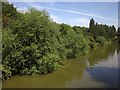
Foliage by The Feeder
Trees and bushes at the edge of Netham Park, seen from Barton Hill Bridge across the canal.
Image: © Derek Harper
Taken: 13 Jul 2013
0.09 miles