IMAGES TAKEN NEAR TO
Netham Road, BRISTOL, BS5 9PQ
Introduction
This page details the photographs taken nearby to Netham Road, BS5 9PQ by members of the Geograph project.
The Geograph project started in 2005 with the aim of publishing, organising and preserving representative images for every square kilometre of Great Britain, Ireland and the Isle of Man.

There are currently over 7.5m images from over14,400 individuals and you can help contribute to the project by visiting https://www.geograph.org.uk
Image Map
Images are licensed for reuse under creativecommons.org/licenses/by-sa/2.0
Notes
- Clicking on the map will re-center to the selected point.
- The higher the marker number, the further away the image location is from the centre of the postcode.
Image Listing (72 Images Found)
Images are licensed for reuse under creativecommons.org/licenses/by-sa/2.0
Image
Details
Distance
1
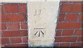
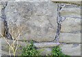
Ordnance Survey Cut Mark
This OS cut mark can be found on No100 Blackswarth Road. It marks a point 35.701m above mean sea level.
Image: © Adrian Dust
Taken: 19 Jul 2021
0.06 miles
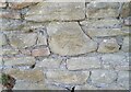
2
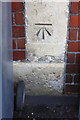
Benchmark on #100 Blackswarth Road (Grindell Road face)
Ordnance Survey cut mark benchmark described on the Bench Mark Database at http://www.bench-marks.org.uk/bm84270
Image: © Roger Templeman
Taken: 2 May 2017
0.06 miles
3
#100A Blackswarth Road, Grindell Road
There is an OS benchmark Image on the stone column at the junction of the houses right of the right hand wheelie bin
Image: © Roger Templeman
Taken: 2 May 2017
0.06 miles
4
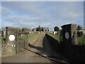
Entrance to Avon View Cemetery from Blackswarth Road
A dead straight path into the lower end of the cemetery lies on what were previously allotments. Quarrying was a major industry just further towards the river.
Image: © Neil Owen
Taken: 2 Feb 2022
0.06 miles
5
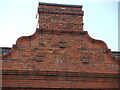
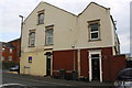
Crowned by a date
The former Three Crowns pub is over two hundred years old, now a residential property. The date of 1904 is prominent on the front, which perhaps indicates a rebuilding in the past. See Image] for a look at the present appearance.
Image: © Neil Owen
Taken: 2 Feb 2022
0.08 miles
6
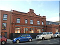
Lost crowns
This was the old Three Crowns pub of not so long ago. It had served the community for over two hundred years but finally pulled its last pint in 2017. Despite appeals, the approval was given to convert it into flats, which opened in 2021. The space to the left of shot used to be the garden but now has a new brick structure up against the old pub. See Image] for a detail of the facade.
Image: © Neil Owen
Taken: 2 Feb 2022
0.08 miles
7
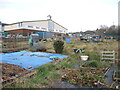
Blackswarth allotments
Some of Netham's land has been preserved for food production along Fireclay Road. It should be noted that this area used to be covered with an extensive heavy industry complex in the nineteenth century, known locally as the Brillos. The Netham Works used to manufacture chemical products, chiefly Sodium Carbonate (washing soda). The company imported a plant from Spain called Barilla, soon to be corrupted to Brillo, which contained 25% of the substance. As the business came under pressure from others, it folded and the area became regenerated in the 1950s; today there are many non-chemical firms operating in some larger buildings, but the odd patch of allotments still survive.
Image: © Neil Owen
Taken: 2 Feb 2022
0.09 miles
8
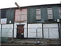
Going through many changes
An industrial unit on Netham Road is looking like it is about to go. A few small businesses still operated here in less than opulent surroundings. This latter twentieth century building was once a leather dressing factory, but has gone through many changes of occupation since.
Image: © Neil Owen
Taken: 2 Feb 2022
0.09 miles
9
Ordnance Survey Cut Mark
This OS cut mark can be found on the wall at the rear of No34 Cooperage Road. It marks a point 95.4ft above mean sea level.
Image: © Adrian Dust
Taken: 19 Jul 2021
0.09 miles
10
Ordnance Survey Cut Mark
This OS cut mark can be found on the wall at the rear of No34 Cooperage Road. It marks a point 28.569m above mean sea level.
Image: © Adrian Dust
Taken: 19 Jul 2021
0.10 miles