IMAGES TAKEN NEAR TO
Morse Road, BRISTOL, BS5 9LD
Introduction
This page details the photographs taken nearby to Morse Road, BS5 9LD by members of the Geograph project.
The Geograph project started in 2005 with the aim of publishing, organising and preserving representative images for every square kilometre of Great Britain, Ireland and the Isle of Man.

There are currently over 7.5m images from over14,400 individuals and you can help contribute to the project by visiting https://www.geograph.org.uk
Image Map
Images are licensed for reuse under creativecommons.org/licenses/by-sa/2.0
Notes
- Clicking on the map will re-center to the selected point.
- The higher the marker number, the further away the image location is from the centre of the postcode.
Image Listing (81 Images Found)
Images are licensed for reuse under creativecommons.org/licenses/by-sa/2.0
Image
Details
Distance
1
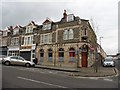
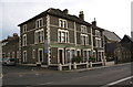
Morse Road
Looking along a terraced street between Church Road and Victoria Avenue.
Image: © DS Pugh
Taken: 27 Jun 2017
0.01 miles
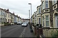
2
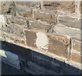
#102 Church Road at junction with Witchell Road
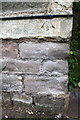
There is an OS benchmark Image on the wide corner stone above 4 small stone quoins at the near corner, left hand face, of the house
Image: © Roger Templeman
Taken: 29 Oct 2016
0.04 miles
3
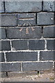
Ordnance Survey Cut Mark
This OS cut mark can be found on No102 Church Road. It marks a point 26.316m above mean sea level.
Image: © Adrian Dust
Taken: 19 Jul 2021
0.04 miles
4
Benchmark on #102 Church Road
Ordnance Survey cut mark benchmark described on the Bench Mark Database at http://www.bench-marks.org.uk/bm80342
Image: © Roger Templeman
Taken: 29 Oct 2016
0.04 miles
5
Benchmark on #42 Verrier Road
Ordnance Survey cut mark benchmark described on the Bench Mark Database at http://www.bench-marks.org.uk/bm80344
Image: © Roger Templeman
Taken: 29 Oct 2016
0.05 miles
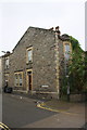
6
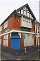
Neighbourhood Office, #42 Verrier Road at Victoria Avenue junction
There is an OS benchmark Image on the left hand face of the building near its junction with the boundary wall. The building is owned by Bristol City Council and houses the Mental Health Team Neighbourhood Office.
Image: © Roger Templeman
Taken: 29 Oct 2016
0.05 miles
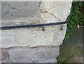
7
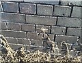
Ordnance Survey Cut Mark
This OS cut mark can be found on No42 Verrier Road. It marks a point 30.815m above mean sea level.
Image: © Adrian Dust
Taken: 19 Jul 2021
0.05 miles
8
Ordnance Survey Cut Mark
This cement splodge covers an OS cut mark on No76 Church Road. It marked a point 24.299m above mean sea level.
Image: © Adrian Dust
Taken: 19 Jul 2021
0.05 miles
9
#76 Church Road, 'Byron House', at Byron Street junction
St Matthew's Church is at the right hand edge of the image
Image: © Roger Templeman
Taken: 2 May 2017
0.05 miles