IMAGES TAKEN NEAR TO
Whitehall Road, BRISTOL, BS5 9BJ
Introduction
This page details the photographs taken nearby to Whitehall Road, BS5 9BJ by members of the Geograph project.
The Geograph project started in 2005 with the aim of publishing, organising and preserving representative images for every square kilometre of Great Britain, Ireland and the Isle of Man.

There are currently over 7.5m images from over14,400 individuals and you can help contribute to the project by visiting https://www.geograph.org.uk
Image Map
Images are licensed for reuse under creativecommons.org/licenses/by-sa/2.0
Notes
- Clicking on the map will re-center to the selected point.
- The higher the marker number, the further away the image location is from the centre of the postcode.
Image Listing (46 Images Found)
Images are licensed for reuse under creativecommons.org/licenses/by-sa/2.0
Image
Details
Distance
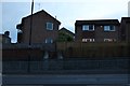
1
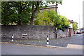
Junction of Devon Road and Whitehall Road
There is an OS benchmark Image on the stone wall under the Devon Road name sign
Image: © Roger Templeman
Taken: 29 Oct 2016
0.06 miles
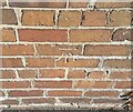
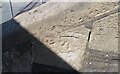
2
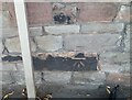
Ordnance Survey Cut Mark
This OS cut mark can be found on the wall east side of Devon Road. It marks a point 31.998m above mean sea level.
Image: © Adrian Dust
Taken: 19 Jul 2021
0.07 miles
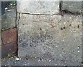
3
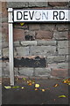
Benchmark on Devon Road wall
Ordnance Survey cut mark benchmark described on the Bench Mark Database at http://www.bench-marks.org.uk/bm80343
Image: © Roger Templeman
Taken: 29 Oct 2016
0.07 miles
6
Ordnance Survey Cut Mark
This OS cut mark can be found on No36 Victoria Parade. It marks a point 29.986m above mean sea level.
Image: © Adrian Dust
Taken: 19 Jul 2021
0.12 miles
7
Ordnance Survey Cut Mark
This worn OS cut mark can be found on No79 Whitehall Road. It marks a point 24.921m above mean sea level.
Image: © Adrian Dust
Taken: 19 Jul 2021
0.15 miles
8
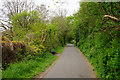
Bristol and Bath Railway Path
One of the first former railways to be developed into a cycle route, now part of National Cycle Route 4. I understand there have been plans to convert this route to a guided busway, but also that it is currently safe as it is.
Image: © Bill Boaden
Taken: 14 Apr 2017
0.15 miles
9
Ordnance Survey Cut Mark
This OS cut mark can be found on the steps of the Chapel, Whitehall Road. It marks a point 38.033m above mean sea level.
Image: © Adrian Dust
Taken: 19 Jul 2021
0.16 miles
10
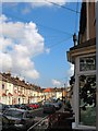
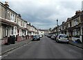
A typical Redfield Street
Victorian terraces in Redfield / St George
Image: © Duncan Gammon
Taken: 23 Jun 2006
0.16 miles