IMAGES TAKEN NEAR TO
Westminster Road, BRISTOL, BS5 9AN
Introduction
This page details the photographs taken nearby to Westminster Road, BS5 9AN by members of the Geograph project.
The Geograph project started in 2005 with the aim of publishing, organising and preserving representative images for every square kilometre of Great Britain, Ireland and the Isle of Man.

There are currently over 7.5m images from over14,400 individuals and you can help contribute to the project by visiting https://www.geograph.org.uk
Image Map
Images are licensed for reuse under creativecommons.org/licenses/by-sa/2.0
Notes
- Clicking on the map will re-center to the selected point.
- The higher the marker number, the further away the image location is from the centre of the postcode.
Image Listing (41 Images Found)
Images are licensed for reuse under creativecommons.org/licenses/by-sa/2.0
Image
Details
Distance
2
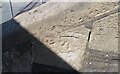
Ordnance Survey Cut Mark
This OS cut mark can be found on the steps of the Chapel, Whitehall Road. It marks a point 38.033m above mean sea level.
Image: © Adrian Dust
Taken: 19 Jul 2021
0.06 miles
3
Ordnance Survey Cut Mark
This OS cut mark can be found on the Pavilion, Whitehall Gardens. It marks a point 41.020m above mean sea level.
Image: © Adrian Dust
Taken: 19 Jul 2021
0.08 miles
5
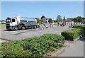
... and not a drop to drink!
Local householders form a queue, rescued from a mains leak by a Bristol Water tanker.
Image: © Anthony O'Neil
Taken: 30 May 2020
0.13 miles
8
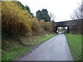
Cyclist on the Bristol and Bath Railway Path
Heading south-west under the Devon Road bridge.
Image: © Christine Johnstone
Taken: 23 Mar 2013
0.14 miles
9
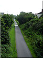
Bristol to Bath Cycle Path
Looking down on the Bristol to Bath cycle path, which was the first cycle route created by Sustrans (which celebrates its 30th birthday in July 2007). Taken looking down from the bridge on Devon Road in Easton. Compare the sky with one taken the opposite direction just before Image
Image: © Linda Bailey
Taken: 1 Jul 2007
0.14 miles
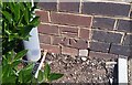
10
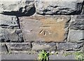
Ordnance Survey Cut Mark
This OS cut mark can be found on the west parapet of the railway bridge on Devon Road. It marks a point 37.259m above mean sea level.
Image: © Adrian Dust
Taken: 19 Jul 2021
0.15 miles