IMAGES TAKEN NEAR TO
Petersway Gardens, BRISTOL, BS5 8TA
Introduction
This page details the photographs taken nearby to Petersway Gardens, BS5 8TA by members of the Geograph project.
The Geograph project started in 2005 with the aim of publishing, organising and preserving representative images for every square kilometre of Great Britain, Ireland and the Isle of Man.

There are currently over 7.5m images from over14,400 individuals and you can help contribute to the project by visiting https://www.geograph.org.uk
Image Map
Images are licensed for reuse under creativecommons.org/licenses/by-sa/2.0
Notes
- Clicking on the map will re-center to the selected point.
- The higher the marker number, the further away the image location is from the centre of the postcode.
Image Listing (17 Images Found)
Images are licensed for reuse under creativecommons.org/licenses/by-sa/2.0
Image
Details
Distance
1

Gunters hill junction with Nibletts Hill
St Georges, Bristol.
Housing built close to the River Severn.
Image: © Anthony Vosper
Taken: 25 Jun 2022
0.06 miles
2
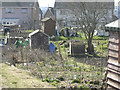
The Allotments, Nicholas Lane, Bristol
The allotments, looking south towards the rear of the houses on Nibblets Hill taken from near the allotment shop.
Image: © Andy Gilbert
Taken: 6 Mar 2005
0.12 miles
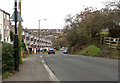
3
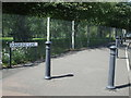
Dundridge Lane
The pavement has been protected by a line of bollards. The park behind must be a popular place that people leave their cars by.
Image: © Neil Owen
Taken: 30 Jul 2020
0.16 miles
4
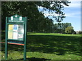
Dundridge Park Playing Fields
A welcoming notice to the green space. The area was historically part of the old Kingswood Forest centuries ago. After that, there was a Dundridge Farm that occupied the higher ground above the old quarries. The land was bought by Bristol City Council in 1940 and partly given over to Dig For Victory plots. Following that, it became the popular public green space it is now. Some of the old farm buildings were converted into changing rooms for various sporting teams.
Image: © Neil Owen
Taken: 30 Jul 2020
0.16 miles
5
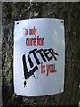
The only cure for litter
A salutary notice on a tree in Dundridge Park.
Image: © Neil Owen
Taken: 30 Jul 2020
0.17 miles
6
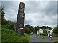
Old industrial chimney on Trooper's Hill Road
Image: © Roger Cornfoot
Taken: 7 Jun 2021
0.20 miles
7
Access to Troopers hill Nature Reserve
Once a mining area now given over to nature.
Image: © Anthony Vosper
Taken: 3 Mar 2024
0.20 miles
8
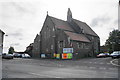
St Aidan with St George
An Anglican church which also hosts regular arts events.
Image: © Bill Boaden
Taken: 28 Sep 2017
0.20 miles
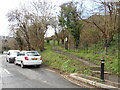
9
2010 : Troopers Hill Road, St.George, Bristol
Troopers Hill is steep all the way down from Air Balloon Road to Crew's Hole Road at the bottom, this is the really steep bit.
The footpath on the right leads to Troopers Hill proper, an area where coal and copper were mined and clay for bricks was quarried. It is now a nature reserve.
Houses in St. Anne's Park on the other side of the Bristol Avon are seen in the background.
Image: © Maurice Pullin
Taken: 26 Nov 2010
0.21 miles
10
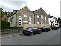
Chapel Conversion on Crew's Hill Road
Image: © Roger Cornfoot
Taken: 7 Jun 2021
0.21 miles