IMAGES TAKEN NEAR TO
Furnwood, BRISTOL, BS5 8ST
Introduction
This page details the photographs taken nearby to Furnwood, BS5 8ST by members of the Geograph project.
The Geograph project started in 2005 with the aim of publishing, organising and preserving representative images for every square kilometre of Great Britain, Ireland and the Isle of Man.

There are currently over 7.5m images from over14,400 individuals and you can help contribute to the project by visiting https://www.geograph.org.uk
Image Map
Images are licensed for reuse under creativecommons.org/licenses/by-sa/2.0
Notes
- Clicking on the map will re-center to the selected point.
- The higher the marker number, the further away the image location is from the centre of the postcode.
Image Listing (23 Images Found)
Images are licensed for reuse under creativecommons.org/licenses/by-sa/2.0
Image
Details
Distance
1

Gunters hill junction with Nibletts Hill
St Georges, Bristol.
Housing built close to the River Severn.
Image: © Anthony Vosper
Taken: 25 Jun 2022
0.14 miles
2
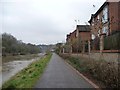
Riverside homes, north-east bank of the Avon
On Avon Close, off Crews Hole Road [formerly an industrial site].
Image: © Christine Johnstone
Taken: 23 Mar 2013
0.16 miles
3
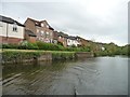
Riverside housing off Crews Hole Road
Once smelly industry, now smart houses and a holiday destination.
Image: © Christine Johnstone
Taken: 3 May 2015
0.16 miles
4
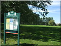
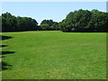
Dundridge Park Playing Fields
A welcoming notice to the green space. The area was historically part of the old Kingswood Forest centuries ago. After that, there was a Dundridge Farm that occupied the higher ground above the old quarries. The land was bought by Bristol City Council in 1940 and partly given over to Dig For Victory plots. Following that, it became the popular public green space it is now. Some of the old farm buildings were converted into changing rooms for various sporting teams.
Image: © Neil Owen
Taken: 30 Jul 2020
0.17 miles
5
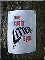
The only cure for litter
A salutary notice on a tree in Dundridge Park.
Image: © Neil Owen
Taken: 30 Jul 2020
0.17 miles
6
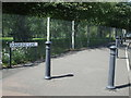
Dundridge Lane
The pavement has been protected by a line of bollards. The park behind must be a popular place that people leave their cars by.
Image: © Neil Owen
Taken: 30 Jul 2020
0.18 miles
7
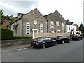
Chapel Conversion on Crew's Hill Road
Image: © Roger Cornfoot
Taken: 7 Jun 2021
0.18 miles
8
Dundridge Park open space
The old farmland is now a popular and refreshing green space. In times gone by the steep slopes beyond the trees were busy stone quarries. This area is not designated as a model aeroplane/drone flying zone.
Image: © Neil Owen
Taken: 30 Jul 2020
0.19 miles
9
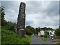
Old industrial chimney on Trooper's Hill Road
Image: © Roger Cornfoot
Taken: 7 Jun 2021
0.19 miles
10
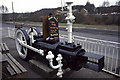
Steam Engine, Bull Inn, 333 Crew's Hole Road
The pub is still there but this steam engine has been taken for private preservation. It is a C Isler steam driven compressor from Crew's Hole, Tar Distillery. This distillery was commenced by I K Brunel in 1843 to produce a preservative for the GWR sleepers. It was latterly owned by British Steel Corporation and closed in 1981. The quayside village also shown in this square is on the site of the works.
Image: © Chris Allen
Taken: 9 Apr 1996
0.19 miles