IMAGES TAKEN NEAR TO
Holly Lodge Road, BRISTOL, BS5 7UD
Introduction
This page details the photographs taken nearby to Holly Lodge Road, BS5 7UD by members of the Geograph project.
The Geograph project started in 2005 with the aim of publishing, organising and preserving representative images for every square kilometre of Great Britain, Ireland and the Isle of Man.

There are currently over 7.5m images from over14,400 individuals and you can help contribute to the project by visiting https://www.geograph.org.uk
Image Map
Images are licensed for reuse under creativecommons.org/licenses/by-sa/2.0
Notes
- Clicking on the map will re-center to the selected point.
- The higher the marker number, the further away the image location is from the centre of the postcode.
Image Listing (8 Images Found)
Images are licensed for reuse under creativecommons.org/licenses/by-sa/2.0
Image
Details
Distance
1
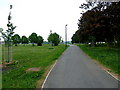
Cycle path and playing fields at Clay Hill, Bristol
Image: © Anthony O'Neil
Taken: 29 Apr 2011
0.05 miles
3
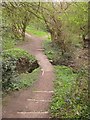
Footpath, Coombe Brook Valley
A path connecting Mayfield Park and Holly Close crosses a tributary of the River Frome. Information about the nature park/reserve is at http://www.avonwildlifetrust.org.uk/reserves/coombe_brook.htm .
Image: © Derek Harper
Taken: 31 Mar 2012
0.16 miles
4
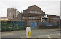
Speedwell Swimming Baths
The baths, which are in the midst of allotments, opened in the 1930s and closed in 2005, and were on the market in 2008 with consent for demolition and redevelopment for 32 flats on four floors. Some internal shots at http://www.28dayslater.co.uk/forums/showthread.php?t=64489 . In the foreground is Whitefield Road, the B4465. Behind is Roegate House, which has 83 flats.
Image: © Derek Harper
Taken: 31 Mar 2012
0.17 miles
5
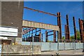
Bristol : Demolition
A demolition seems to be taking place on Deep Pit Road.
Image: © Lewis Clarke
Taken: 10 Aug 2022
0.20 miles
6
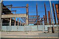
Bristol : Demolition
A demolition seems to be taking place on Deep Pit Road.
Image: © Lewis Clarke
Taken: 10 Aug 2022
0.21 miles
7
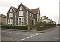
House in Mayfield Park
At the corner of Mayfield Park North (left). Beyond is more modern housing.
Image: © Derek Harper
Taken: 31 Mar 2012
0.22 miles
8
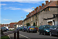
2011 : Poplar Road, Speedwell, Bristol
A residential road between Whitefield Road and Speedwell Road.
Image: © Maurice Pullin
Taken: 19 Aug 2011
0.23 miles