IMAGES TAKEN NEAR TO
Freemantle Road, BRISTOL, BS5 6SY
Introduction
This page details the photographs taken nearby to Freemantle Road, BS5 6SY by members of the Geograph project.
The Geograph project started in 2005 with the aim of publishing, organising and preserving representative images for every square kilometre of Great Britain, Ireland and the Isle of Man.

There are currently over 7.5m images from over14,400 individuals and you can help contribute to the project by visiting https://www.geograph.org.uk
Image Map
Images are licensed for reuse under creativecommons.org/licenses/by-sa/2.0
Notes
- Clicking on the map will re-center to the selected point.
- The higher the marker number, the further away the image location is from the centre of the postcode.
Image Listing (54 Images Found)
Images are licensed for reuse under creativecommons.org/licenses/by-sa/2.0
Image
Details
Distance
1
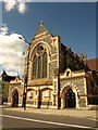
New Testament Church Of God, Bristol
The church is on Fishponds Road, the A432, and must date from the late C19. It was formerly St Thomas the Apostle Church, and is also mapped as a Pentecostal church.
Image: © Derek Harper
Taken: 7 Sep 2013
0.06 miles
2
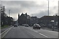
Bristol : Eastville - Muller Road
Muller Road heading though Bristol towards Fishponds Road.
Image: © Lewis Clarke
Taken: 1 Feb 2013
0.09 miles
3
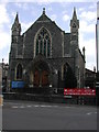
BRISTOL Eastville Park Methodist Church
Originally built as a United Free Methodist Chapel, it is now a Pentecostal church. More history on http://www.churchcrawler.pwp.blueyonder.co.uk/bristol3/ufrmeth.htm
Image: © ChurchCrawler
Taken: 23 May 2004
0.09 miles
5
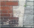
Ordnance Survey Cut Mark
This OS cut mark can be found on No122 Fishponds Road. It marks a point 25.173m above mean sea level.
Image: © Adrian Dust
Taken: 19 Jul 2021
0.09 miles
6
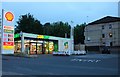
Subway on Muller Road, Eastville
Part of the Shell petrol station
Image: © David Howard
Taken: 1 Jun 2019
0.09 miles
8
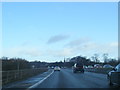
Junction 2 on the M32, near Eastville, Bristol
Image: © Roger Cornfoot
Taken: 28 Oct 2010
0.10 miles
9
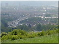
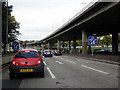
Arterial motorway
Looking from Purdown gives lots of panoramic views of central and northern Bristol. Down in the Frome valley, the M32 reaches into the heart of the business district, rising over the rooftops of the nineteenth century terraced houses.
Image: © Neil Owen
Taken: 13 May 2016
0.10 miles
