IMAGES TAKEN NEAR TO
Coombe Road, BRISTOL, BS5 6LE
Introduction
This page details the photographs taken nearby to Coombe Road, BS5 6LE by members of the Geograph project.
The Geograph project started in 2005 with the aim of publishing, organising and preserving representative images for every square kilometre of Great Britain, Ireland and the Isle of Man.

There are currently over 7.5m images from over14,400 individuals and you can help contribute to the project by visiting https://www.geograph.org.uk
Image Map
Images are licensed for reuse under creativecommons.org/licenses/by-sa/2.0
Notes
- Clicking on the map will re-center to the selected point.
- The higher the marker number, the further away the image location is from the centre of the postcode.
Image Listing (32 Images Found)
Images are licensed for reuse under creativecommons.org/licenses/by-sa/2.0
Image
Details
Distance
1
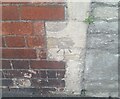
Ordnance Survey Cut Mark
This OS cut mark can be found on No122 Fishponds Road. It marks a point 25.173m above mean sea level.
Image: © Adrian Dust
Taken: 19 Jul 2021
0.07 miles
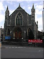
2
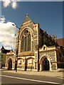
New Testament Church Of God, Bristol
The church is on Fishponds Road, the A432, and must date from the late C19. It was formerly St Thomas the Apostle Church, and is also mapped as a Pentecostal church.
Image: © Derek Harper
Taken: 7 Sep 2013
0.09 miles
3

An evening of redness in the west
Looking out the back of Gadshill Road towards Stapleton Road, not sure of the name of the sillhouted church , will find out.
Image: © clive
Taken: 2 Aug 2006
0.09 miles
4
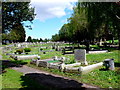
Greenbank Cemetery
This large cemetery on the north east side of Bristol is in between Eastville and Lower Easton. The prominent headstone is to Joy, the young daughter of Winifred Edith Ellen Solomon and Percy Cyril Solomon.
Image: © Nigel Mykura
Taken: 11 May 2012
0.11 miles
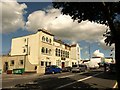
5
BRISTOL Eastville Park Methodist Church
Originally built as a United Free Methodist Chapel, it is now a Pentecostal church. More history on http://www.churchcrawler.pwp.blueyonder.co.uk/bristol3/ufrmeth.htm
Image: © ChurchCrawler
Taken: 23 May 2004
0.13 miles
6
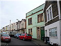
Gloucester Street
This is a narrow twisting street of terraced housing that rises up from Fishponds Rd the A432 in Eastville next to Eastville Park.
Image: © Nigel Mykura
Taken: 23 Feb 2013
0.14 miles
7
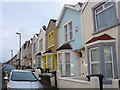
Gloucester Street
This narrow street of terraced housing runs from Fishponds Rd in Eastville to Greenbank View near the cemetery.
Image: © Nigel Mykura
Taken: 23 Feb 2013
0.15 miles
8
Bristol Sikh Temple
Shri Guru Nanak Prakash Singh Sabha Gurdwara was established in smaller premises in 1958; the move to this late C19 building on Fishponds Road took place in 1977 http://www.bristolsikhtemple.co.uk/ .
Image shows this row from the other direction; the further building has been repainted.
Image: © Derek Harper
Taken: 7 Sep 2013
0.15 miles
9
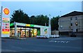
Subway on Muller Road, Eastville
Part of the Shell petrol station
Image: © David Howard
Taken: 1 Jun 2019
0.15 miles