IMAGES TAKEN NEAR TO
Ducie Road Business Park, BRISTOL, BS5 0AF
Introduction
This page details the photographs taken nearby to Ducie Road Business Park, BS5 0AF by members of the Geograph project.
The Geograph project started in 2005 with the aim of publishing, organising and preserving representative images for every square kilometre of Great Britain, Ireland and the Isle of Man.

There are currently over 7.5m images from over14,400 individuals and you can help contribute to the project by visiting https://www.geograph.org.uk
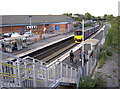
Image Map
Images are licensed for reuse under creativecommons.org/licenses/by-sa/2.0
Notes
- Clicking on the map will re-center to the selected point.
- The higher the marker number, the further away the image location is from the centre of the postcode.
Image Listing (88 Images Found)
Images are licensed for reuse under creativecommons.org/licenses/by-sa/2.0
Image
Details
Distance
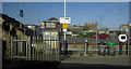
1
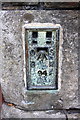
Benchmark on Church Road wall near Lawrence Hill Station
Ordnance Survey flush bracket (serial number 94) benchmark described on the Bench Mark Database at http://www.bench-marks.org.uk/bm9762
Image: © Roger Templeman
Taken: 29 Oct 2016
0.03 miles
2
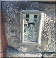
Ordnance Survey Flush Bracket (94)
This OS Flush Bracket can be found on the north side of Church Road. It marks a point 20.751m above mean sea level.
Image: © Adrian Dust
Taken: 19 Jul 2021
0.03 miles
3
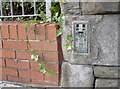
Lawrence Hill flush bracket
A flush bracket on the bridge over the railway station, number 94 in the line from Flax Bourton to Sharpness and is from the Second Geodetic Levelling, dating from the early part of the twentieth century. See http://www.bench-marks.org.uk/bm9762 for the entry in the Benchmark Database and Image] for a wider view.
Image: © Neil Owen
Taken: 1 Oct 2012
0.03 miles
4
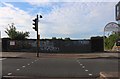
Railway bridge at Lawrence Hill Station
Image: © David Howard
Taken: 1 Jun 2019
0.03 miles
5
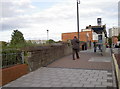
Church Road bridge
The road takes a little rise over the railway line, with the station below - see Image A flush bracket can be discovered on the approach between the old stonework and the brick courses - see Image
Image: © Neil Owen
Taken: 1 Oct 2012
0.04 miles
6
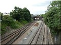
Railway lines, south of Lawrence Hill station
Image: © Roger Cornfoot
Taken: 7 Jun 2021
0.04 miles
7
Railway at Lawrence Hill
View from Ducie Road.
Image: © Wayland Smith
Taken: 23 Apr 2010
0.04 miles
8
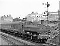
Severn Beach - Bristol Temple Meads local at Lawrence Hill, 1959
View northward, towards Stapleton Road, beyond which the line from Severn Beach via Avonmouth joins the main line from Filton Junction and everywhere else west north and east. The locomotive is '8750' class 0-6-0PT no. 8790 (built 2/34, withdrawn 5/62).
Image: © Ben Brooksbank
Taken: 8 Aug 1959
0.05 miles
9
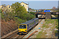
Commuter train home
A local service arrives for the workers and shoppers at Lawrence Hill station.
Image: © Neil Owen
Taken: 1 Oct 2012
0.05 miles
10
Lawrence Hill station
With the Lidl car park in the background.
Image: © Derek Harper
Taken: 1 Apr 2019
0.05 miles