IMAGES TAKEN NEAR TO
Mulberry Road, BRISTOL, BS49 5HD
Introduction
This page details the photographs taken nearby to Mulberry Road, BS49 5HD by members of the Geograph project.
The Geograph project started in 2005 with the aim of publishing, organising and preserving representative images for every square kilometre of Great Britain, Ireland and the Isle of Man.

There are currently over 7.5m images from over14,400 individuals and you can help contribute to the project by visiting https://www.geograph.org.uk
Image Map
Images are licensed for reuse under creativecommons.org/licenses/by-sa/2.0
Notes
- Clicking on the map will re-center to the selected point.
- The higher the marker number, the further away the image location is from the centre of the postcode.
Image Listing (5 Images Found)
Images are licensed for reuse under creativecommons.org/licenses/by-sa/2.0
Image
Details
Distance
1
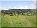
Either way from Venus Street
The footpath splits into two: the Two Rivers to the right, Congresbury to the left.
Image: © Neil Owen
Taken: 19 May 2021
0.13 miles
2
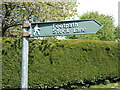
Footpath sign on Venus Street
A classic cast alloy sign from the old Royal Label Factory. There are a few such types in the area.
Image: © Neil Owen
Taken: 19 May 2021
0.13 miles
4
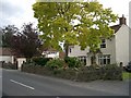
The Lawns, 24 Brinsea Road
Much altered cottage originally built c. 1780's. Outbuildings were once the village butcher's shop.
Image: © Wayne Faunt
Taken: 11 Jul 2007
0.21 miles
5
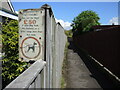
Park Road sign for dogs
The notice specifically differentiates between verges of 4m width. It is also property of Woodspring council - now defunct.
Image: © Neil Owen
Taken: 19 May 2021
0.23 miles