IMAGES TAKEN NEAR TO
Station Road, BRISTOL, BS49 5DY
Introduction
This page details the photographs taken nearby to Station Road, BS49 5DY by members of the Geograph project.
The Geograph project started in 2005 with the aim of publishing, organising and preserving representative images for every square kilometre of Great Britain, Ireland and the Isle of Man.

There are currently over 7.5m images from over14,400 individuals and you can help contribute to the project by visiting https://www.geograph.org.uk
Image Map
Images are licensed for reuse under creativecommons.org/licenses/by-sa/2.0
Notes
- Clicking on the map will re-center to the selected point.
- The higher the marker number, the further away the image location is from the centre of the postcode.
Image Listing (208 Images Found)
Images are licensed for reuse under creativecommons.org/licenses/by-sa/2.0
Image
Details
Distance
2
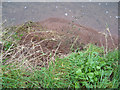
New Front Congresbury
The Old Red Sandstone, Marl and river alluvium form a new front for the stream flow on the Yeo River, Congresbury, this being the older river side and with a recessed slip to the west; the new river levee protecting the bungalows, to the south and behind, on this south bank opposite the geese and farm. The sediment has slipped into and surged forward below the water, the persistent flow and wet aiding slide of the particles, but it is likely there is a deeper slip plane carrying this feature forward as the mound of soil is well into the stream and of a convex form, rather than a cut back erosion from the streamflow.
Image: © MDS
Taken: 13 Feb 2007
0.02 miles
3
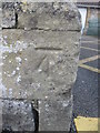
Ordnance Survey Cut Mark
This OS cut mark can be found on the front of the school. It marks a point 6.334m above mean sea level.
Image: © Adrian Dust
Taken: 16 Mar 2016
0.02 miles
4
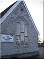
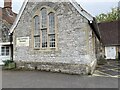
The Old School Rooms
Congresbury has a long history of the church and education. When St Andrew's church was consecrated in the thirteenth century it offered a number of uses for the community and a school was kept there. The Court House was used as a village school until a new building was created in 1871 - the one seen here. It served the village into the 1970s when the church land to the rear was used for the current schools.
These days the old school is used for a variety of purposes, such as local council meetings, clubs and help groups.
On this corner of the old school is a benchmark - see Image
Image: © Neil Owen
Taken: 31 Dec 2013
0.03 miles
5
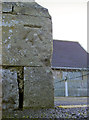
Old school benchmark
This cutmark on the old school rooms on Station Road dates back to the later twentieth century. See http://www.bench-marks.org.uk/bm53616 for the entry in the Benchmark Database and Image] for a wider view.
Image: © Neil Owen
Taken: 31 Dec 2013
0.03 miles
6

Congresbury : The Old School Rooms
The building can be booked either as a whole venue or as individual rooms.
Image: © Lewis Clarke
Taken: 24 Jan 2022
0.03 miles
8

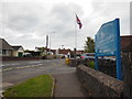
Congresbury : The Old School Rooms
A sign welcomes people to St Andrew's Church nearby.
Image: © Lewis Clarke
Taken: 24 Jan 2022
0.03 miles
9
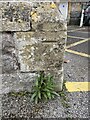
OS Cut Mark
https://www.bench-marks.org.uk/bm53616
Image: © thejackrustles
Taken: 28 Apr 2022
0.03 miles