IMAGES TAKEN NEAR TO
Rock Road, BRISTOL, BS49 4JE
Introduction
This page details the photographs taken nearby to Rock Road, BS49 4JE by members of the Geograph project.
The Geograph project started in 2005 with the aim of publishing, organising and preserving representative images for every square kilometre of Great Britain, Ireland and the Isle of Man.

There are currently over 7.5m images from over14,400 individuals and you can help contribute to the project by visiting https://www.geograph.org.uk
Image Map
Images are licensed for reuse under creativecommons.org/licenses/by-sa/2.0
Notes
- Clicking on the map will re-center to the selected point.
- The higher the marker number, the further away the image location is from the centre of the postcode.
Image Listing (139 Images Found)
Images are licensed for reuse under creativecommons.org/licenses/by-sa/2.0
Image
Details
Distance
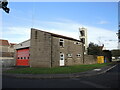
2
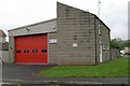
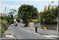
Yatton Fire Station
Yatton Fire Station, Rock Road, Yatton, Bristol is station number 19 of Avon Fire & Rescue Service
Image: © Kevin Hale
Taken: 8 May 2006
0.02 miles
3
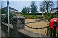
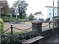
Yatton War Memorial Garden
Located on the corner of High Street and Rock Road.
The memorial garden was created in 1920. It was restored in 2004, with support from Yatton Horticultural Society and Yatton Rotary Club.
This was formerly the location of the village pound, where stray animals were enclosed.
Image: © Jaggery
Taken: 23 Jul 2011
0.03 miles
4
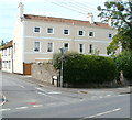
Grade II listed Rock House, Yatton
Mid 18th century house on the corner of High Street and Rock Road. Grade II listed in October 1961.
Image: © Jaggery
Taken: 23 Jul 2011
0.03 miles
5
SE end of High Street, Yatton
This part of High Street has a semirural appearance. Viewed from near the Claverham Road junction looking towards the Rock Road junction.
Image: © Jaggery
Taken: 23 Jul 2011
0.03 miles
6
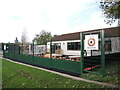
Yatton Junior F.C. clubhouse
The sports ground includes a 3G artificial pitch.
Image: © Neil Owen
Taken: 29 Oct 2021
0.03 miles
7
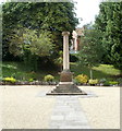
Yatton : War Memorial
The war memorial in Yatton.
Image: © Lewis Clarke
Taken: 24 Jan 2022
0.05 miles
8
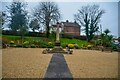
Yatton : War Memorial
Designed by the Reverend F.E. Peert and unveiled on 22nd July 1922 to commemorate the men of the parish who were killed in the First World War. Further inscriptions were added to those who died in the Second World War.
Image: © Lewis Clarke
Taken: 24 Jan 2022
0.05 miles
9
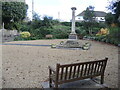
A pound to a column
This enclosed area at the south east end of Yatton was once the pound (where stray farm animals were detained). But in 1920 the local parish council converted it into a war memorial to the men who did not come back. A copper plate on the north face records them, with a second plate on the west for those who also fell in WWII.
The monument is a Clipsham stone column with Ionic capital, designed by the Reverend F.E. Peert and unveiled on 22nd July 1922. Restored in 2004 and Grade II listed.
Image: © Neil Owen
Taken: 29 Oct 2021
0.05 miles
10
A seat by the war memorial
Facing onto the main road is Yatton's space to remember the fallen.
Image: © Neil Owen
Taken: 29 Oct 2021
0.05 miles