IMAGES TAKEN NEAR TO
The Perrings, BRISTOL, BS48 4YQ
Introduction
This page details the photographs taken nearby to The Perrings, BS48 4YQ by members of the Geograph project.
The Geograph project started in 2005 with the aim of publishing, organising and preserving representative images for every square kilometre of Great Britain, Ireland and the Isle of Man.

There are currently over 7.5m images from over14,400 individuals and you can help contribute to the project by visiting https://www.geograph.org.uk
Image Map
Images are licensed for reuse under creativecommons.org/licenses/by-sa/2.0
Notes
- Clicking on the map will re-center to the selected point.
- The higher the marker number, the further away the image location is from the centre of the postcode.
Image Listing (27 Images Found)
Images are licensed for reuse under creativecommons.org/licenses/by-sa/2.0
Image
Details
Distance
1
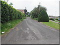
Becket's Lane Nailsea
Looking to the WSW along Becket's Lane from the Queens Road end of the lane.
Image: © Jaggery
Taken: 8 Jun 2016
0.12 miles
2

Wall postbox in Nailsea
Viewed across Becket's Lane near the corner of Queens Road.
Image: © Jaggery
Taken: 8 Jun 2016
0.12 miles
3
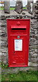
King George V postbox in a Becket's Lane wall, Nailsea
Located here. http://www.geograph.org.uk/photo/5419674
The GR embossed on the box is short for Georgius Rex,
Latin for King George, in this case King George V
who reigned from May 1910-January 1936.
Image: © Jaggery
Taken: 8 Jun 2016
0.12 miles
4
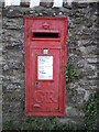
Georgian box on Beckett's Lane
The lane was once the only route through a particularly rural part of the countryside. A Georgian postbox is set in a wall that bounded the few houses that used to be here; these days it is all but surrounded by post-war housing estates. See Image] for a wider view.
Image: © Neil Owen
Taken: 29 Sep 2021
0.12 miles
5
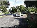
Beckett's Lane was blocked off
Once this road was the only one worth noting, but when modern Nailsea grew rapidly in the post-war housing boom a new road (Queen's Road) was built right across it. The powers decided to block Beckett's to motor traffic.
See Image] for a look at the postbox in the wall.
Image: © Neil Owen
Taken: 29 Sep 2021
0.12 miles
6
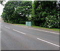
Roadside cabinets, Queens Road, Nailsea
Between Wedmore Road and Ash Hayes Road. The identifier on the cabinet on the right is CC C1BB.
Saint Francis of Assisi Catholic Church is behind the trees.
Image: © Jaggery
Taken: 8 Jun 2016
0.13 miles
7
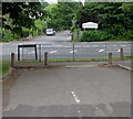
Barriers across the northeast end of Becket's Lane Nailsea
At the Queens Road end of the lane, concrete posts and metal railings block the passage of motor vehicles.
Image: © Jaggery
Taken: 8 Jun 2016
0.13 miles
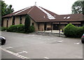
8
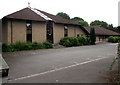
Saint Francis of Assisi Catholic Church, Nailsea
On the south side of Little Meadow End, the church is part of the Roman Catholic Diocese of Clifton. The church was opened for worship by Bishop Mervyn in 1986, though the building was not dedicated until after the debt had been paid off in 1998.
Image: © Jaggery
Taken: 8 Jun 2016
0.15 miles
9
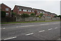
Church Hayes Close houses, Nailsea
The backs of Church Hayes Close houses viewed across Queens Road.
Image: © Jaggery
Taken: 8 Jun 2016
0.15 miles
10
St Francis of Assisi Catholic Church, Nailsea
Accessed from Queens Road via Little Meadow End, the church is part of the Roman Catholic Diocese of Clifton. The church was opened for worship by Bishop Mervyn in 1986, though the building was not dedicated until after the debt had been paid off in 1998.
Image: © Jaggery
Taken: 8 Jun 2016
0.15 miles