IMAGES TAKEN NEAR TO
Barrow Street, BRISTOL, BS48 3SD
Introduction
This page details the photographs taken nearby to Barrow Street, BS48 3SD by members of the Geograph project.
The Geograph project started in 2005 with the aim of publishing, organising and preserving representative images for every square kilometre of Great Britain, Ireland and the Isle of Man.

There are currently over 7.5m images from over14,400 individuals and you can help contribute to the project by visiting https://www.geograph.org.uk
Image Map
Images are licensed for reuse under creativecommons.org/licenses/by-sa/2.0
Notes
- Clicking on the map will re-center to the selected point.
- The higher the marker number, the further away the image location is from the centre of the postcode.
Image Listing (42 Images Found)
Images are licensed for reuse under creativecommons.org/licenses/by-sa/2.0
Image
Details
Distance
2
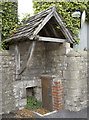
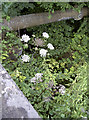
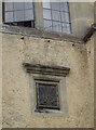
A little shelter
Some intriguing roofing for a small part of the walling. Is it for drainage, or a tiny entrance for the gnome in the pub up the road?
Image: © Neil Owen
Taken: 17 Aug 2017
0.02 miles
4
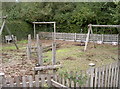
Barrow play area
A small place for younger fun, close to the pub and village green. A sturdy wooden fence prevents anyone falling into the stream beyond.
Image: © Neil Owen
Taken: 17 Aug 2017
0.03 miles
5
Remains of a mill stream
Barrow Gurney has the Land Yeo running through it and has provided power for many mills over the years. A plaque records that here are the remains of a mill noted in the Domesday Book for Upper Barrow Mill that used to grind flour.
Barrow's more recent history is influenced by the construction of the large reservoirs up the road by Bristol Water Works in the late nineteenth century. Transportation of the water was by large pipes that ran through the village, almost in parallel with the Yeo; the pipe here was laid when the B.W.W. bought the Cold Bath stream in 1847 and crossed it at this point.
Image: © Neil Owen
Taken: 17 Aug 2017
0.04 miles
6
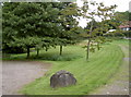
Barrow Gurney Village Green
The stone says so! A Millennium stone, at that.
Image: © Neil Owen
Taken: 17 Aug 2017
0.04 miles
7
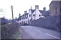
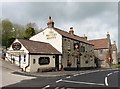
Barrow Gurney Post Office
This scene hasn't changed too much since 1962. The Post office (nearest white building) closed many years ago and traffic management through the narrow village street is now in place.
Image: © Richard Park
Taken: Unknown
0.04 miles
8
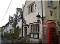
Compton Mead
This row of old cottages have a date over an entrance of 1690. They were extensively remodelled by Henry Martin Gibbs (of the local Gibbs family of Tyntesfield fame) from 1900-27. Grade II listed.
The post office used to run here but was closed a few years ago. Previously in the early twentieth century the office was at the end of the village, close to the modern war memorial and village hall.
Image: © Neil Owen
Taken: 17 Aug 2017
0.04 miles
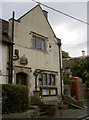
9
A gift from the Gibbs family
The row of old cottages (Compton Mead) date from the late seventeenth century; they were extensively rebuilt in the early twentieth, courtesy of the local Gibbs family. They were wealthy merchants and settled in the area; their main estate was Tyntesfield House, but they also contributed to a lot if the village life. One of William Gibbs' sons, Henry Martin Gibbs, arrived in 1882 and set about major improvements to the village. His initials remain on this plaque on the end of the old Post Office.
Image: © Neil Owen
Taken: 17 Aug 2017
0.04 miles
10
The old Post Office
Barrow Gurney's post office used to be here in the terrace of cottages known as Compton Mead. The cottages are believed to date from the late seventeenth century, with many subsequent works thereafter. However, after many years of service, the office was closed a few years ago. The phone box is bereft of anything useful, like a phone.
Image: © Neil Owen
Taken: 17 Aug 2017
0.04 miles