IMAGES TAKEN NEAR TO
Main Road, BRISTOL, BS48 3QQ
Introduction
This page details the photographs taken nearby to Main Road, BS48 3QQ by members of the Geograph project.
The Geograph project started in 2005 with the aim of publishing, organising and preserving representative images for every square kilometre of Great Britain, Ireland and the Isle of Man.

There are currently over 7.5m images from over14,400 individuals and you can help contribute to the project by visiting https://www.geograph.org.uk
Image Map
Images are licensed for reuse under creativecommons.org/licenses/by-sa/2.0
Notes
- Clicking on the map will re-center to the selected point.
- The higher the marker number, the further away the image location is from the centre of the postcode.
Image Listing (37 Images Found)
Images are licensed for reuse under creativecommons.org/licenses/by-sa/2.0
Image
Details
Distance
1
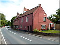
Former Angel Inn, Flax Bourton
Viewed across the A370 Main Road. The former village inn is now in residential use as two dwellings named Old Angel Cottage and Old Angel. No doubt the inn was named with reference to its location opposite the village church. http://www.geograph.org.uk/photo/3713797
A poignant sentence in a brief history of the village records that (in the decades after the Second World War) "the village grocer, general store and post office all followed the Angel Inn, brew house, butcher, carpenter, smithy and tannery into oblivion." Similar losses have occurred in many other villages in the UK.
Image: © Jaggery
Taken: 13 Jul 2012
0.00 miles
2
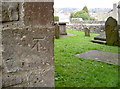
St Michael's benchmark
An eighteenth century Ordnance Survey cutmark, as listed in the Benchmark Database: http://www.bench-marks.org.uk/bm55945 , on the southeast corner of the little church. See Image] for another view.
Image: © Neil Owen
Taken: 24 Mar 2014
0.01 miles
3
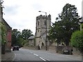
Flax Bourton church
The church of St Michael and All Angels
Image: © David Smith
Taken: 26 Jul 2016
0.01 miles
4
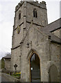
Glass and stone
St Michael and All Angels church dates back to the twelfth century and is Grade II* listed. The small building is still part of the life of the village and now has a modern glass door to welcome worshippers. See Image] for another view.
Image: © Neil Owen
Taken: 24 Mar 2014
0.01 miles
5
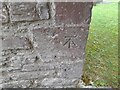
Ordnance Survey Cut Mark
This OS cut mark can be found on the SE angle of St Michael's Church. It marks a point 38.633m above mean sea level.
Image: © Adrian Dust
Taken: 24 Aug 2022
0.01 miles
6
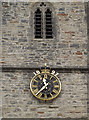
Crowned clock
The clock on the tower of St Michael and All Angels church, with the date of the jubilee of Queen Victoria. See Image] for a benchmark.
Image: © Neil Owen
Taken: 24 Mar 2014
0.01 miles
7
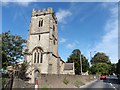
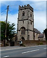
St Michael and All Angels, Flax Bourton
Image: © Roger Cornfoot
Taken: 26 Aug 2020
0.02 miles
8
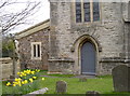
A small yard
St Michael and All Angels church in Flax Bourton was here long before the A370 Weston Road. It has a small but picturesque churchyard, complete with a few gravestones and some seasonal flowers. Unfortunately, it is now right next to the very busy main road. See Image] for a look at the time.
Image: © Neil Owen
Taken: 24 Mar 2014
0.02 miles
9
St Michael and All Angels Church, Flax Bourton
Viewed across the A370 Main Road. The Anglican Parish Church in the Diocese of Bath & Wells
has 12th century origins, with later alterations and a mid 19th century restoration.
Image: © Jaggery
Taken: 13 Jul 2012
0.02 miles
10

OS benchmark - Flax Bourton, church
An OS cutmark on the south-facing wall of St Michael and All Angels church in Flax; originally levelled at 38.633m above Ordnance Datum Newlyn.
Image: © Richard Law
Taken: 30 Jul 2015
0.02 miles