IMAGES TAKEN NEAR TO
Long Lane, BRISTOL, BS48 3EQ
Introduction
This page details the photographs taken nearby to Long Lane, BS48 3EQ by members of the Geograph project.
The Geograph project started in 2005 with the aim of publishing, organising and preserving representative images for every square kilometre of Great Britain, Ireland and the Isle of Man.

There are currently over 7.5m images from over14,400 individuals and you can help contribute to the project by visiting https://www.geograph.org.uk
Image Map
Images are licensed for reuse under creativecommons.org/licenses/by-sa/2.0
Notes
- Clicking on the map will re-center to the selected point.
- The higher the marker number, the further away the image location is from the centre of the postcode.
Image Listing (4 Images Found)
Images are licensed for reuse under creativecommons.org/licenses/by-sa/2.0
Image
Details
Distance
1
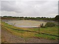
Reservoir
On the OS map this plastic lined area of water is marked as a reservoir. It was not what I had anticipated. The little water remaining in the plastic lined rectangle was sludgy and looked distinctly non-potable.
Image: © Sharon Loxton
Taken: 1 Aug 2006
0.04 miles
2
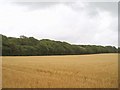
Hyatt's Wood
The western edge of Hyatt's Wood viewed across a ripe field of corn.
Image: © Sharon Loxton
Taken: 1 Aug 2006
0.07 miles
3
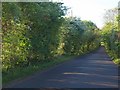
Backwell Hill Road
Early morning sun shining through the hawthorns bordering the straight road to Hyatt's Wood.
Image: © Derek Harper
Taken: 23 May 2010
0.15 miles
4
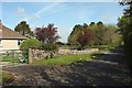
Backwell Hill Road
At the junction with a lane down to Backwell. The road itself leads down to Farleigh and Backwell Green.
Image: © Derek Harper
Taken: 3 May 2016
0.24 miles