IMAGES TAKEN NEAR TO
Trendlewood Way, BRISTOL, BS48 2PF
Introduction
This page details the photographs taken nearby to Trendlewood Way, BS48 2PF by members of the Geograph project.
The Geograph project started in 2005 with the aim of publishing, organising and preserving representative images for every square kilometre of Great Britain, Ireland and the Isle of Man.

There are currently over 7.5m images from over14,400 individuals and you can help contribute to the project by visiting https://www.geograph.org.uk
Image Map (Loading...)


Getting Data...Please wait
Leaflet Map data © OpenStreetMap
Images are licensed for reuse under creativecommons.org/licenses/by-sa/2.0
Notes
- Clicking on the map will re-center to the selected point.
- The higher the marker number, the further away the image location is from the centre of the postcode.
Image Listing (11 Images Found)
Images are licensed for reuse under creativecommons.org/licenses/by-sa/2.0
Image
Details
Distance
1
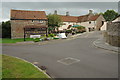
The Old Farmhouse
The Old Farmhouse public house in Nailsea.
Image: © Philip Halling
Taken: 10 Sep 2011
0.01 miles
2
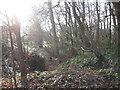
Woodland on the edge of a former sandstone quarry
The local red pennant sandstone was used for roofing.
Image: © Dr Duncan Pepper
Taken: 13 Jan 2012
0.17 miles
3
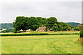
Backwell: Teague?s Colliery
The waste tip of an early 19th century coal mine on Backwell Common, now covered in trees. James Teague (1750-1818), its developer, was an ironmaster and owner of coal pits in the Forest of Dean. For further information see Ralph Anstis, The Industrial Teagues and the Forest of Dean, Allan Sutton, 1990. Seen from one of the numerous public footpaths in the parish
Image: © Martin Bodman
Taken: 6 Jul 2003
0.19 miles
4
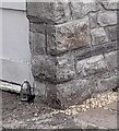
Ordnance Survey Cut Mark
This OS cut mark can be found on the tower SE side of Trendlewood Way. It marks a point 25.393m above mean sea level.
Image: © Adrian Dust
Taken: 30 Jul 2022
0.21 miles
5
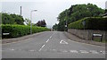
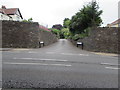
Western end of Trendlewood Way, Nailsea
Viewed across Bucklands Batch.
Image: © Jaggery
Taken: 8 Jun 2016
0.22 miles
6
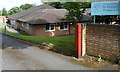
St Francis' Catholic Primary School, Nailsea
Viewed from Station Road.
Image: © Jaggery
Taken: 13 Jul 2012
0.23 miles
7
Station Road directions signs, Nailsea
Facing the eastern end of Queens Road. http://www.geograph.org.uk/photo/5043830
Left (north) on Station Road for Clevedon and Bristol or right for Nailsea & Backwell railway station.
Image: © Jaggery
Taken: 8 Jun 2016
0.24 miles
8
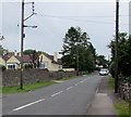
Wires over Station Road, Nailsea
Over Station Road north of the Queens Road junction. http://www.geograph.org.uk/photo/5043830
Image: © Jaggery
Taken: 8 Jun 2016
0.24 miles
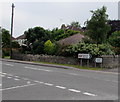
9
Bucklands Drive, Nailsea
Private dead-end road on the east side of Bucklands Batch in the south of Nailsea.
Image: © Jaggery
Taken: 8 Jun 2016
0.24 miles
10
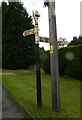
Old Direction Sign - Signpost by Station Road, Nailsea
Pyramid finial - 3 arms; Somerset SCC pyramid (Sheldon) by the UC road, in parish of Nailsea (North Somerset District), Station Road junction with Bucklands Batch and Trendlewood Way, on cut verge by telegraph pole.
To be surveyed
Milestone Society National ID: SO_ST4769
Image: © Alan Rosevear
Taken: 24 Sep 2012
0.24 miles