IMAGES TAKEN NEAR TO
Mayflower Gardens, BRISTOL, BS48 1QW
Introduction
This page details the photographs taken nearby to Mayflower Gardens, BS48 1QW by members of the Geograph project.
The Geograph project started in 2005 with the aim of publishing, organising and preserving representative images for every square kilometre of Great Britain, Ireland and the Isle of Man.

There are currently over 7.5m images from over14,400 individuals and you can help contribute to the project by visiting https://www.geograph.org.uk
Image Map (Loading...)


Getting Data...Please wait
Leaflet Map data © OpenStreetMap
Images are licensed for reuse under creativecommons.org/licenses/by-sa/2.0
Notes
- Clicking on the map will re-center to the selected point.
- The higher the marker number, the further away the image location is from the centre of the postcode.
Image Listing (31 Images Found)
Images are licensed for reuse under creativecommons.org/licenses/by-sa/2.0
Image
Details
Distance
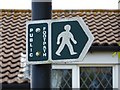
2
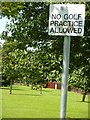
I guess there have been problems with golfers
Not a sign I have seen before, a lot more specific than 'No Ball Games' usually seen.
Image: © Steve Barnes
Taken: 23 Jul 2009
0.10 miles
3
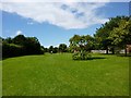
Green Space between houses
Following the sign, (see Image), you encounter a nice green space, but you mustn't practice your golf, see Image
Image: © Steve Barnes
Taken: 23 Jul 2009
0.10 miles
4

Old Oak tree at boundary of former orchard
This tree near the boundary of a former orchard is old enough that it must have been present through the years that the area was an orchard - one can't help wondering how it survived.
Image: © Steve Barnes
Taken: 22 Jul 2009
0.12 miles
6
Must be a short footpath
Actually it is, as it leads from Trendlewood Way, through one of the green areas left by the new construction to the recreation ground on Station Road.
Image: © Steve Barnes
Taken: 23 Jul 2009
0.14 miles
7
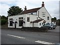
Sawyers Arms - Nailsea
As one heads east this is the last public house in High St, Nailsea before reaching the boundary with Wraxall.
Image: © Steve Barnes
Taken: 22 Jul 2009
0.14 miles
9
Entrance to Footpath through former Orchards
This is the way into a series of green spaces occupying the former orchards of the old cider factory.
Image: © Steve Barnes
Taken: 22 Jul 2009
0.15 miles
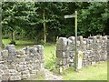
10
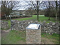
A reminder of Coate's lands
The green space off the B3130 near Nailsea has recently been rewilded with tree saplings. In the not-too-distant past the area around here would have lots of cider apple trees - grown by Redvers Coate. The company flourished from the 1920s until merging with Showerings in 1956, and becoming part of the Gaymers and Whiteways group in 1969. With production moved to Shepton Mallet, the works in Nailsea closed in 1975. An information board here records the history.
Image: © Neil Owen
Taken: 10 Mar 2022
0.15 miles