IMAGES TAKEN NEAR TO
Green Pastures Road, BRISTOL, BS48 1ND
Introduction
This page details the photographs taken nearby to Green Pastures Road, BS48 1ND by members of the Geograph project.
The Geograph project started in 2005 with the aim of publishing, organising and preserving representative images for every square kilometre of Great Britain, Ireland and the Isle of Man.

There are currently over 7.5m images from over14,400 individuals and you can help contribute to the project by visiting https://www.geograph.org.uk
Image Map (Loading...)


Getting Data...Please wait
Leaflet Map data © OpenStreetMap
Images are licensed for reuse under creativecommons.org/licenses/by-sa/2.0
Notes
- Clicking on the map will re-center to the selected point.
- The higher the marker number, the further away the image location is from the centre of the postcode.
Image Listing (7 Images Found)
Images are licensed for reuse under creativecommons.org/licenses/by-sa/2.0
Image
Details
Distance
2
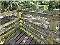
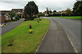
Green Pastures Pond
This water feature, at the north-east corner of the housing of Nailsea, is marked on the OS 25 inch (1892-1914) as a rectangular reed bed. Its field parcel number was 681, and its acreage was 0.392 (all this detail was recorded on those maps). It is not named on OS maps, but it is Green Pastures Pond on Google Earth. The south-west corner is partly cut off by the curve of Green Pastures Road.
Image: © Neville Goodman
Taken: 27 Jul 2023
0.07 miles
5
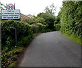
Please RESPECT the speed limit, Nailsea
The sign is alongside Lodge Lane in the East End area of Nailsea.
Image: © Jaggery
Taken: 13 Jul 2012
0.23 miles
7
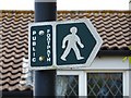
Must be a short footpath
Actually it is, as it leads from Trendlewood Way, through one of the green areas left by the new construction to the recreation ground on Station Road.
Image: © Steve Barnes
Taken: 23 Jul 2009
0.24 miles