IMAGES TAKEN NEAR TO
High Street, BRISTOL, BS48 1AU
Introduction
This page details the photographs taken nearby to High Street, BS48 1AU by members of the Geograph project.
The Geograph project started in 2005 with the aim of publishing, organising and preserving representative images for every square kilometre of Great Britain, Ireland and the Isle of Man.

There are currently over 7.5m images from over14,400 individuals and you can help contribute to the project by visiting https://www.geograph.org.uk
Image Map (Loading...)


Getting Data...Please wait
Leaflet Map data © OpenStreetMap
Images are licensed for reuse under creativecommons.org/licenses/by-sa/2.0
Notes
- Clicking on the map will re-center to the selected point.
- The higher the marker number, the further away the image location is from the centre of the postcode.
Image Listing (91 Images Found)
Images are licensed for reuse under creativecommons.org/licenses/by-sa/2.0
Image
Details
Distance
1
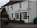
Nailsea Dentists
This dental practice is housed in what looks like a former village shop.
Image: © Steve Barnes
Taken: 22 Jul 2009
0.03 miles
2
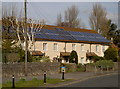
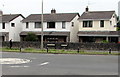
Solar terrace
A row of houses at the end of the High Street with occupiers that have a keen interest in the amount of sunshine available.
Image: © Neil Owen
Taken: 6 Mar 2012
0.08 miles
3
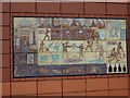
Site history on Tesco Nailsea
This it one of two pictograms commemorating the former glass factory from 1788.
Image: © Steve Barnes
Taken: 20 Jul 2009
0.08 miles
5
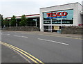
Tesco Superstore, Nailsea
Viewed across Brockway in June 2016 when the store is open from 6am to midnight every day except Sunday (10am-4pm).
Image: © Jaggery
Taken: 8 Jun 2016
0.10 miles
6
B3130 from Stock Way North to High Street, Nailsea
The mini-roundabout at the northern end of Brockway is where the B3130 Stock Way North on the left becomes the B3130 High Street on the right. The two street name signs are alongside the wall to the right of the lamppost.
Image: © Jaggery
Taken: 8 Jun 2016
0.10 miles
7
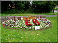
Nailsea WI flowerbed
The Women's Institute flowerbed is on the corner of Brockway and Stock Way North in Nailsea. http://www.geograph.org.uk/photo/4993228
Image: © Jaggery
Taken: 8 Jun 2016
0.11 miles
8
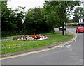
Colourful corner of Nailsea
One of many floral displays in Nailsea in June 2016, this one is on the corner of Brockway and Stock Way North. http://www.geograph.org.uk/photo/4993181 to a closer view.
Image: © Jaggery
Taken: 8 Jun 2016
0.11 miles
9
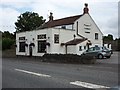
Sawyers Arms - Nailsea
As one heads east this is the last public house in High St, Nailsea before reaching the boundary with Wraxall.
Image: © Steve Barnes
Taken: 22 Jul 2009
0.12 miles
10
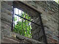
A window on the winding tower
The disused Middle Engine Pit colliery winding tower is open to the elements, leaving it on Historic England's 'At Risk' list. The pit opened in 1790 and provided work for many generations of villagers, but closed around the turn of the 1900s. The remains of the site and its buildings were largely neglected or demolished for the new town centre, but those that have survived are some of the finest nineteenth century colliery heritage in the country. Grade II listed.
Image: © Neil Owen
Taken: 29 Sep 2021
0.12 miles