IMAGES TAKEN NEAR TO
Riverside Business Park, St. Annes Road, BRISTOL, BS4 4ED
Introduction
This page details the photographs taken nearby to Riverside Business Park, St. Annes Road, BS4 4ED by members of the Geograph project.
The Geograph project started in 2005 with the aim of publishing, organising and preserving representative images for every square kilometre of Great Britain, Ireland and the Isle of Man.

There are currently over 7.5m images from over14,400 individuals and you can help contribute to the project by visiting https://www.geograph.org.uk
Image Map
Images are licensed for reuse under creativecommons.org/licenses/by-sa/2.0
Notes
- Clicking on the map will re-center to the selected point.
- The higher the marker number, the further away the image location is from the centre of the postcode.
Image Listing (73 Images Found)
Images are licensed for reuse under creativecommons.org/licenses/by-sa/2.0
Image
Details
Distance
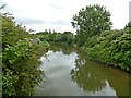
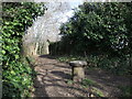
2
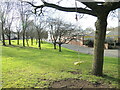
A swing by the bridge
The St Anne's part of Bristol has long been associated with some large industries that congregated near the River Avon. Even so, a little green space is utilised by a resourceful community.
Image: © Neil Owen
Taken: 2 Feb 2022
0.04 miles
3
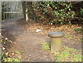
2011 : Bollard near New Brislington Bridge, a blast from the past
Out of sight of the River Avon now this bollard was probably used by craft waiting for the tide to take them into Bristol Docks. Although the Avon was made navigable to Bath in 1727 Bristol Docks were tidal until: "Construction started in 1804 to build the tidal New Cut and divert the River Avon along the Feeder Canal to the harbour; a system designed and built by William Jessop and later improved by Isambard Kingdom Brunel." from http://en.wikipedia.org/wiki/Netham_Lock
Image: © Maurice Pullin
Taken: 14 Feb 2011
0.05 miles
4
Retail and commercial units along St Anne's Road
The typical trading estate mix of offices and industrial units, beyond which are the modern flats of Weavers Mill Close.
Image: © Neil Owen
Taken: 7 Mar 2012
0.06 miles
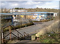
5
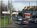
2011 : Rush hour on Newbridge Road, St. Anne's
It is always rush hour on Newbridge Road and for miles around - rush?
Congestion caused by the amount of traffic using this link between Brislington to the south and Redfield to the north combined with the narrow bridge at the end of the Feeder Canal Image]
Image: © Maurice Pullin
Taken: 14 Feb 2011
0.06 miles
6
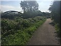
Kennet & Avon Canal Walk
Kennet & Avon Canal Walk by the River Avon heading to Netham Lock
Image: © Shaun Ferguson
Taken: 5 May 2018
0.07 miles
7
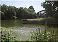
River Avon and The Feeder
Going their separate ways either side of this promontory, the river on the far side.
Image: © Derek Harper
Taken: 13 Jul 2013
0.08 miles
8
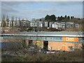
Industry and housing in St Anne's
Close to the industrial units and warehouses are some modern apartments on the Weavers Mill area. They lie further past the banks of the River Avon.
Image: © Neil Owen
Taken: 2 Feb 2022
0.08 miles
9
Moor room
An old mooring post still makes for a useful bollard to the path that runs along the south banks of the River Avon. In the past this stretch of the river would have been largely a place to moor boats before the enormous board mills were built (and demolished) in the twentieth century.
Image: © Neil Owen
Taken: 2 Feb 2022
0.08 miles
10
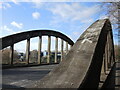
New Brislington Bridge
A concrete construction crossing the Avon close to the junction with the New Cut. A bridge was built in the late nineteenth century but this version is a newer one.
Image: © Neil Owen
Taken: 2 Feb 2022
0.09 miles