IMAGES TAKEN NEAR TO
Woodside Road, BRISTOL, BS4 4DP
Introduction
This page details the photographs taken nearby to Woodside Road, BS4 4DP by members of the Geograph project.
The Geograph project started in 2005 with the aim of publishing, organising and preserving representative images for every square kilometre of Great Britain, Ireland and the Isle of Man.

There are currently over 7.5m images from over14,400 individuals and you can help contribute to the project by visiting https://www.geograph.org.uk
Image Map
Images are licensed for reuse under creativecommons.org/licenses/by-sa/2.0
Notes
- Clicking on the map will re-center to the selected point.
- The higher the marker number, the further away the image location is from the centre of the postcode.
Image Listing (54 Images Found)
Images are licensed for reuse under creativecommons.org/licenses/by-sa/2.0
Image
Details
Distance
1
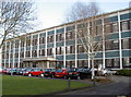
St Anne's House
Part of Bristol City Council's Neighbourhood and Housing Services.
Image: © Neil Owen
Taken: 7 Mar 2012
0.05 miles
2
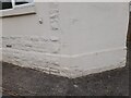
Ordnance Survey Cut Mark
This OS cut mark can be found on No102 Newbridge Road. It marks a point 29.035m above mean sea level.
Image: © Adrian Dust
Taken: 22 Apr 2022
0.08 miles
3
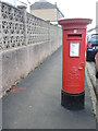
Letterbox on Highworth Road
A Georgian example, standing in a road that was previously called Addison Road before the Second World War.
Image: © Neil Owen
Taken: 2 Feb 2022
0.08 miles
4
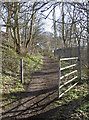
Gate, St Anne's Park
Open for visitors on foot or two wheels.
Image: © Neil Owen
Taken: 7 Mar 2012
0.09 miles
5
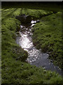
Fresh growth
The warm Spring sunshine and a ready supply of water makes for good growing conditions.
Image: © Neil Owen
Taken: 7 Mar 2012
0.09 miles
6
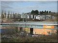
Industry and housing in St Anne's
Close to the industrial units and warehouses are some modern apartments on the Weavers Mill area. They lie further past the banks of the River Avon.
Image: © Neil Owen
Taken: 2 Feb 2022
0.10 miles
7
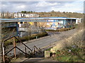
Retail and commercial units along St Anne's Road
The typical trading estate mix of offices and industrial units, beyond which are the modern flats of Weavers Mill Close.
Image: © Neil Owen
Taken: 7 Mar 2012
0.10 miles
8
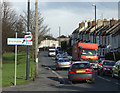
2011 : Rush hour on Newbridge Road, St. Anne's
It is always rush hour on Newbridge Road and for miles around - rush?
Congestion caused by the amount of traffic using this link between Brislington to the south and Redfield to the north combined with the narrow bridge at the end of the Feeder Canal Image]
Image: © Maurice Pullin
Taken: 14 Feb 2011
0.11 miles
9
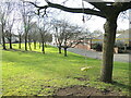
A swing by the bridge
The St Anne's part of Bristol has long been associated with some large industries that congregated near the River Avon. Even so, a little green space is utilised by a resourceful community.
Image: © Neil Owen
Taken: 2 Feb 2022
0.11 miles
10
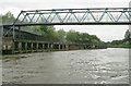
St Anne's Footbridge
Looking downstream along the quayside of the former St Anne's Board Mills site. The north end of the bridge is in Image
Image: © Pierre Terre
Taken: 20 May 2006
0.12 miles