IMAGES TAKEN NEAR TO
Whitby Road, BRISTOL, BS4 4AR
Introduction
This page details the photographs taken nearby to Whitby Road, BS4 4AR by members of the Geograph project.
The Geograph project started in 2005 with the aim of publishing, organising and preserving representative images for every square kilometre of Great Britain, Ireland and the Isle of Man.

There are currently over 7.5m images from over14,400 individuals and you can help contribute to the project by visiting https://www.geograph.org.uk
Image Map
Images are licensed for reuse under creativecommons.org/licenses/by-sa/2.0
Notes
- Clicking on the map will re-center to the selected point.
- The higher the marker number, the further away the image location is from the centre of the postcode.
Image Listing (90 Images Found)
Images are licensed for reuse under creativecommons.org/licenses/by-sa/2.0
Image
Details
Distance
1
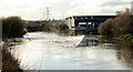
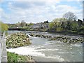
2011 : Tide weir on the River Avon
Between Netham and St.Anne's. Seen from New Brislington Bridge.
The weir was built to hold water in the River Avon for navigation, tidal effects can be felt as far upstream as Keynsham.
Image: © Maurice Pullin
Taken: 14 Feb 2011
0.05 miles
2
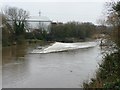
Tidal weir on the unnavigable River Avon
Maintains the navigable level upstream of New Brislington Bridge [from which the photo was taken].
Image: © Christine Johnstone
Taken: 23 Mar 2013
0.05 miles
3
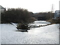
The weather's been rough recently
Strong winds and rain have cleared out some of the more vulnerable vegetation along the Avon. Some bits are big enough to flush downstream but too big to navigate Netham weir.
Image: © Neil Owen
Taken: 2 Feb 2022
0.05 miles
4
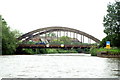
River Avon, New Brislington Bridge
The river heads under the bridge to Netham Weir. Boats head right for Netham Lock and the Feeder Canal.
Image: © Pierre Terre
Taken: 20 May 2006
0.06 miles
5
Netham Dam and New Brislington Bridge
Until the early 1800's, Bristol Docks were tidal, which made it awkward unloading ships. This weir was built to keep the water level in the Floating Harbour constant, and a new channel was dug for the River Avon to flow down. Although the river is theoretically tidal as far as Keynsham Lock, the effects of tides are much reduced upstream of this point. The same spot, seen from the opposite direction, can be seen here Image]
Image: © Antony Dixon
Taken: 16 Apr 2012
0.06 miles
7
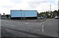
Junction of Whitby Road and Feeder Road
There used to be a warehouse here
Image: © Roger Templeman
Taken: 2 May 2017
0.08 miles
8
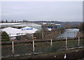
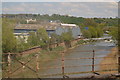
River Avon: Brislington New Bridge and Netham Weir
This photograph of Brislington New Bridge and Netham Weir was taken from a train window while crossing the river Avon.
Image: © Vieve Forward
Taken: 6 Feb 2012
0.09 miles
9

Bridges of the Avon Cut (14/15)
New Brislington Bridge, beyond Netham Weir. No passage here to the continuation of the navigable Avon towards Bath except via Bristol's Floating Harbour and the Feeder Canal to nearby Netham Lock.
Image: © Anthony O'Neil
Taken: 24 Oct 2015
0.09 miles
10
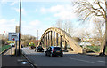
2011 : New Brislington Bridge, Feeder Road, St.Anne's, Bristol
A reinforced concrete structure, dating around 1930 (it was new then).
Crosses the River Avon a few yards above the tidal weir. The river above the weir is navigable as far as Bath having access to Bristol Docks via The Feeder Canal.
The bridge provides an essential link between Redfield, Pile Marsh and other areas north of the river and St.Anne's and Brislington to the south. The next road-bridge upstream is the (A4174) ring road (there is a footbridge at ST 621 730).
Thanks to advice from fellow Geographer Stephen Richards have been able to find the following http://en.wikipedia.org/wiki/Bridgeport_Lamp_Chimney_Company_Bowstring_Concrete_Arch_Bridge from this have been able to establish this is a Bowstring Concrete Arch Bridge and my guestimate of around 1930 was probably not far out. For more information see the link.
Image: © Maurice Pullin
Taken: 14 Feb 2011
0.09 miles