IMAGES TAKEN NEAR TO
New Walls, BRISTOL, BS4 3TA
Introduction
This page details the photographs taken nearby to New Walls, BS4 3TA by members of the Geograph project.
The Geograph project started in 2005 with the aim of publishing, organising and preserving representative images for every square kilometre of Great Britain, Ireland and the Isle of Man.

There are currently over 7.5m images from over14,400 individuals and you can help contribute to the project by visiting https://www.geograph.org.uk
Image Map
Images are licensed for reuse under creativecommons.org/licenses/by-sa/2.0
Notes
- Clicking on the map will re-center to the selected point.
- The higher the marker number, the further away the image location is from the centre of the postcode.
Image Listing (321 Images Found)
Images are licensed for reuse under creativecommons.org/licenses/by-sa/2.0
Image
Details
Distance
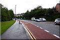
3
Totterdown, Bristol
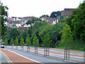
The bin lorry is stationary at traffic lights on the A4, i.e. the main Bristol - Bath road, and beyond it, in the trees, is an entrance/exit into the Bath Road/St Philip's (suburb) section of the St Philip's Greenway cycle route. This image was ‘snapped’ by the photographer whilst standing at the side of the A37, at the intersection of these two roads, looking towards Bristol city centre. The finger post with pierced lettering indicate the routes to Bath and Wells. This early C19th cast-iron column with three glass balloon lamps is Grade II* listed. It was apparently restored in 1985.
Image: © David Hallam-Jones
Taken: 11 Aug 2017
0.04 miles
4
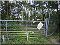
Entry knot allowed
A sign states that the wasteland beside the Bath Road is contaminated with the dangerously invasive Japanese Knotweed.
Image: © Neil Owen
Taken: 11 Sep 2021
0.04 miles
5
Bath Road
A strange place to plant trees. Totterdown is in the background.
Image: © Thomas Nugent
Taken: 2 Aug 2011
0.05 miles
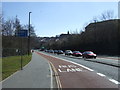
6
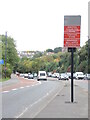
The Zone is coming!
Bristol's traffic-clogged roads are said to be causing excessive amounts of pollution in town. To cure that, a Clean Air Zone is about to be imposed on traffic entering along the Bath Road (A4). Warning notices have been placed on the major routes, preparing people for the charges soon to be set.
Recent tests of the number-plate recognition cameras have sent warning letters to several cars in other parts of the country and whose owners have not been anywhere near Bristol. The date when charges will go live has been out back until late November.
Image: © Neil Owen
Taken: 25 Oct 2022
0.05 miles
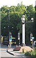
7
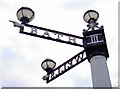
The Three Lamps finger post
An old and familiar landmark in the roads of south Bristol, the post marks the junction of two of the main roads: the A4 Bath Road and the A37 Wells Road. The cast iron edifice was made by Winwood and Co in 1883. It stood here for many years before being removed while the area was heavily bulldozed to satisfy plans for a much bigger road system in the 1960-70s. It was then lost (as was the road system plan!) and the area left flattened. But it was refurbished in the mid-1980s and re-sited here once more. Grade II* listed.
See Image] for a contextual view.
Image: © Neil Owen
Taken: 10 Feb 2017
0.05 miles
8
Totterdown, Bristol
An Augustinian friary known as the Austin Friary was established in 1313 when Simon de Montecute gave a group of friars 100 square feet (9.3 m2 ) of land within the Temple Gate of Bristol. This religious group constructed a pipe system to supply themselves with water from a reservoir on the west bank of the Avon, the reservoir being fed from a spring. This spring site is on “Pylle Hill”, a word thought to be derived from the Welsh word pil, meaning a creek, a term used in this area. Apparently this piped water system served its purpose until the C19th. The prior and six remaining friars surrendered the friary, its contents and vestments to commissioner Richard Youngworth in 1538 during the Dissolution of the Monasteries. The red car is parked on Cambridge Street and the other vehicles on Bellevue Road.
Image: © David Hallam-Jones
Taken: 11 Aug 2017
0.05 miles
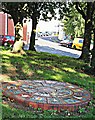
9
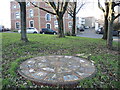
Marking the Ravenswell
Bristol was a much smaller settlement in the early days, some distance north of this local spot of Pylle Hill. A clean spring rose near here, known as Ravenswell, and was used to supply the people. It was diverted into a conduit that went to the town and was then managed by the monks of Austin Friars in 1370.
As a nod to the importance of the water supply, this circular mosaic has been created. Although a little dirty today, the design features some iconic water symbols. In fact, the well is not directly underneath it, but the Cistern is not far away just beyond the Three Lamps junction.
Image: © Neil Owen
Taken: 20 Jan 2022
0.06 miles
10

'The Bishop of Bath and Wells'
The old fingerpost at the Three Lamps junction, a magnificent structure Pevsner referred to as 'The Bishop of Bath and Wells', and one of the finest C19 posts in England. See Image] for the:
'Cast-iron column and glass lamps. Fluted Doric column and square entablature with triglyphs, carrying two finger posts with pointing hands and pierced lettering, indicating 'Bath' and 'Wells'. Restored c1985 with three glass balloon lamps.'
Image: © Neil Owen
Taken: 10 Feb 2017
0.06 miles