IMAGES TAKEN NEAR TO
Whitby Road, BRISTOL, BS4 3QH
Introduction
This page details the photographs taken nearby to Whitby Road, BS4 3QH by members of the Geograph project.
The Geograph project started in 2005 with the aim of publishing, organising and preserving representative images for every square kilometre of Great Britain, Ireland and the Isle of Man.

There are currently over 7.5m images from over14,400 individuals and you can help contribute to the project by visiting https://www.geograph.org.uk
Image Map
Images are licensed for reuse under creativecommons.org/licenses/by-sa/2.0
Notes
- Clicking on the map will re-center to the selected point.
- The higher the marker number, the further away the image location is from the centre of the postcode.
Image Listing (82 Images Found)
Images are licensed for reuse under creativecommons.org/licenses/by-sa/2.0
Image
Details
Distance
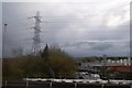
1
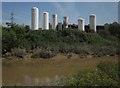
Gas cylinders, BOC, Bristol
Seen from the Avon (flowing to the right) from the River Avon Trail.
Image: © Derek Harper
Taken: 13 Jul 2013
0.02 miles
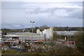
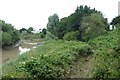
2
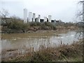
Storage tanks, off Whitby Road
Seen across the River Avon's New Cut.
Image: © Christine Johnstone
Taken: 23 Mar 2013
0.02 miles
3
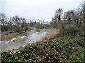
The New Cut of the River Avon
The tidal New Cut was created between 1804 and 1809. It is parallel to the original river further north, which was impounded at the same time to create Bristol's floating harbour.
Image: © Christine Johnstone
Taken: 23 Mar 2013
0.05 miles
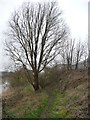
4
River Avon Trail
Upstream from Avon Bridge, the trail becomes much less straightforward than downstream, and is no longer accompanied by NCN3.
Image: © Derek Harper
Taken: 13 Jul 2013
0.05 miles
5
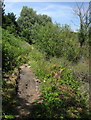
Public footpath on the banks of the New Cut
This is a long distance path, but not a cycle route.
Image: © Christine Johnstone
Taken: 23 Mar 2013
0.05 miles
6

Path beside the Avon
Looking along the banks of the River Avon with a footpath along them. When I got to the other end there was a sign saying the paths were closed due to erosion, but I'd seen no signs from this end. The path was difficult and muddy when I did it.
Image: © DS Pugh
Taken: 27 Jun 2017
0.05 miles
7
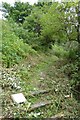
Sign and fence
The sign explained the path along the river bank was closed due to erosion and the difficulty in passing. I'd come from the other end and hadn't passed a sign. The path had been mown, but was hard going and very muddy with multiple chunks of path missing.
Image: © DS Pugh
Taken: 27 Jun 2017
0.06 miles
10
Mown path along the river bank
Looking along the banks of the River Avon with a footpath along them. When I got to the other end there was a sign saying the paths were closed due to erosion, but I'd seen no signs from this end. The path was difficult and muddy when I did it.
Image: © DS Pugh
Taken: 27 Jun 2017
0.07 miles