IMAGES TAKEN NEAR TO
Beaconsfield Road, BRISTOL, BS4 2JF
Introduction
This page details the photographs taken nearby to Beaconsfield Road, BS4 2JF by members of the Geograph project.
The Geograph project started in 2005 with the aim of publishing, organising and preserving representative images for every square kilometre of Great Britain, Ireland and the Isle of Man.

There are currently over 7.5m images from over14,400 individuals and you can help contribute to the project by visiting https://www.geograph.org.uk
Image Map
Images are licensed for reuse under creativecommons.org/licenses/by-sa/2.0
Notes
- Clicking on the map will re-center to the selected point.
- The higher the marker number, the further away the image location is from the centre of the postcode.
Image Listing (105 Images Found)
Images are licensed for reuse under creativecommons.org/licenses/by-sa/2.0
Image
Details
Distance
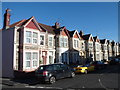
1
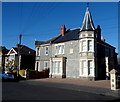
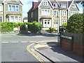
23 and 25 Beaconsfield Road, Knowle, Bristol
Viewed from the corner of Maxse Road. These two semi-detached houses are bigger than, and distinctly different from, neighbouring houses. A stone inscription on the wall shows the year 1902.
Image: © Jaggery
Taken: 11 Nov 2012
0.02 miles
2
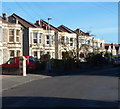
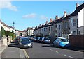
Houses at the eastern end of Beaconsfield Road, Knowle, Bristol
Viewed from the corner of Maxse Road looking towards Harrowdene Road.
Image: © Jaggery
Taken: 11 Nov 2012
0.03 miles
3
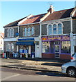
Xing Wang, Knowle, Bristol
Chinese takeaway at 17 Harrowdene Road.
Its neighbour on the left is Star Value, convenience store and off licence.
Image: © Jaggery
Taken: 11 Nov 2012
0.04 miles
4
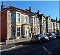
Harrowdene Road houses, Knowle, Bristol
Viewed from near the corner of Beaconsfield Road.
Image: © Jaggery
Taken: 11 Nov 2012
0.06 miles
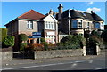
5
Hampden Road, Knowle, Bristol
Houses on the north side of Hampden Road viewed from Harrowdene Road.
Image: © Jaggery
Taken: 11 Nov 2012
0.07 miles
6
Cleve House School, Knowle, Bristol
The school is at 254 Wells Road, opposite Woodbridge Road.
The school has been on this site since 1948. Originally named Arcadia, Cleve House on the right was built in 1887 by Charles Beavis, a Victorian entrepreneur. It became known locally as the Lemonade Palace, because C.E.Beavis manufactured soft drinks in Jacob Street in the old market area of Bristol.
Image: © Jaggery
Taken: 11 Nov 2012
0.08 miles
7
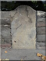
Old Milestone, A37, Wells Road Upper Knowle
The milestone is located outside no. 260, inset into the wall, on the north east side of the road. Parish of Bristol ( City of Bristol district). Stone post (plate lost), erected by the Bristol turnpike trust in the 19th century.
Milestone Society National ID: SO_BRCT01
Image: © Roadside Relics
Taken: 16 Nov 2021
0.09 miles
8
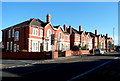
Wells Road houses, Knowle, Bristol
Houses on the north side of Wells Road between Somerset Road and Beaconsfield Road.
The George http://www.geograph.org.uk/photo/3224676 is out of shot on the left.
Image: © Jaggery
Taken: 11 Nov 2012
0.10 miles
9
#248 and #250 Wells Road from Norton Road
#248 is a dentist practice; #250 is where I lived 1953-1960.
Image: © Roger Templeman
Taken: 28 Aug 2010
0.10 miles
10
Hengrove Road, Knowle, Bristol
Viewed from the Redcatch Road end looking towards Wells Road.
Image: © Jaggery
Taken: 11 Nov 2012
0.10 miles