IMAGES TAKEN NEAR TO
Throgmorton Road, BRISTOL, BS4 1HP
Introduction
This page details the photographs taken nearby to Throgmorton Road, BS4 1HP by members of the Geograph project.
The Geograph project started in 2005 with the aim of publishing, organising and preserving representative images for every square kilometre of Great Britain, Ireland and the Isle of Man.

There are currently over 7.5m images from over14,400 individuals and you can help contribute to the project by visiting https://www.geograph.org.uk
Image Map
Images are licensed for reuse under creativecommons.org/licenses/by-sa/2.0
Notes
- Clicking on the map will re-center to the selected point.
- The higher the marker number, the further away the image location is from the centre of the postcode.
Image Listing (10 Images Found)
Images are licensed for reuse under creativecommons.org/licenses/by-sa/2.0
Image
Details
Distance
1
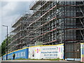
A walk to work
The Airport Road is now much changed as the large high-rise homes are being built.
Image: © Neil Owen
Taken: 12 May 2022
0.11 miles
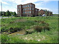
2
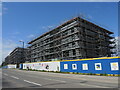
Bo Klok on the Brook
A long strip of grassland runs beside the brook through this part of Knowle, also marking what became the Airport Road. Having missed the large housing development after WWI, the land has finally been allotted housing development of its own. The developers are a partnership between Skanska and IKEA, and are building a large number of high-density homes for various sorts of owners.
Image: © Neil Owen
Taken: 12 May 2022
0.13 miles
3
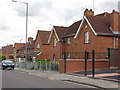
Typical 1930s housing Newquay Road, Knowle West, Bristol
Typical of the original garden estate housing of the 1930s Knowle West council estate.
Image: © Jez McNeill
Taken: 30 Aug 2011
0.13 miles
4
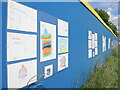
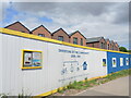
Appealing to future buyers
The new houses going up on Airport Road have long hoardings. In one particular spot, the boards are covered with contributions from local primary schoolchildren. Quite what the developers expect from the coloured in drawings in open to speculation. Maybe they will be customers of the next generations.
Image: © Neil Owen
Taken: 12 May 2022
0.14 miles
5
Investing in the community
The new homes are being snapped up, despite the amounts of money and lack of car parking. Still, the environment is being acknowledged in the build.
Image: © Neil Owen
Taken: 12 May 2022
0.15 miles
6
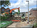
Getting the lights sorted
Plenty of work is needed to ensure the new houses have enough public facilities and provision.
Image: © Neil Owen
Taken: 12 May 2022
0.21 miles
7
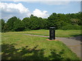
A bit of green on the old farm
This small but open public space was Hengrove Farm, and the area here north-west from the buildings was a quarry.
Image: © Neil Owen
Taken: 7 May 2020
0.21 miles
8
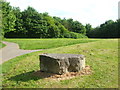
A small matter of a limestone block
It may seem out of place but this block is a small reminder of the fact that this patch of green was once a quarry.
Image: © Neil Owen
Taken: 7 May 2020
0.22 miles
9
A new pond for the new business park
The Filwood Green Business Park is a pretty recent addition to the area. Previously this was the northern end of Whitchurch Airport, which saw vital service in WWII before being closed in the late 1950s. There is a brook that runs across the Airport Road but this pond is part of the latest landscaping; the buildings occupy the site of one of the hangars.
Image: © Neil Owen
Taken: 12 May 2022
0.22 miles
10
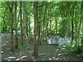
Where the trolleys come to roost
The patch of woodland on the old Hengrove Farm quarry site seems to be a breeding ground for them.
Image: © Neil Owen
Taken: 7 May 2020
0.23 miles