IMAGES TAKEN NEAR TO
Glebe Road, BRISTOL, BS41 9LH
Introduction
This page details the photographs taken nearby to Glebe Road, BS41 9LH by members of the Geograph project.
The Geograph project started in 2005 with the aim of publishing, organising and preserving representative images for every square kilometre of Great Britain, Ireland and the Isle of Man.

There are currently over 7.5m images from over14,400 individuals and you can help contribute to the project by visiting https://www.geograph.org.uk
Image Map (Loading...)


Getting Data...Please wait
Leaflet Map data © OpenStreetMap
Images are licensed for reuse under creativecommons.org/licenses/by-sa/2.0
Notes
- Clicking on the map will re-center to the selected point.
- The higher the marker number, the further away the image location is from the centre of the postcode.
Image Listing (45 Images Found)
Images are licensed for reuse under creativecommons.org/licenses/by-sa/2.0
Image
Details
Distance
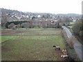
3
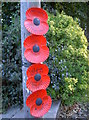
Poppies at the top of Yanley Lane
Long Ashton's tribute to the fallen of WWI features many of these large poppies on roadside poles. Each has a hand-written description of a man and his regiment. The writing seems to be that of school pupils.
Image: © Neil Owen
Taken: 2 Nov 2018
0.10 miles
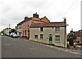
4
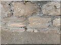
Ordnance Survey Cut Mark
This OS cut mark can be found on No107 Long Ashton Road. It marks a point 40.295m above mean sea level.
Image: © Adrian Dust
Taken: 23 Aug 2022
0.10 miles
5
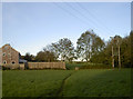
Beside the Ashton Brook
The footpath long outdates the 1960s housing here as it follows close to the brook.
Image: © Neil Owen
Taken: 2 Nov 2018
0.12 miles
6
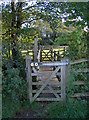
Spanning Ashton Brook
A wooden bridge and part of the Long Ashton circular village walk.
Image: © Neil Owen
Taken: 2 Nov 2018
0.13 miles
7
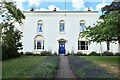
The Glebe: former vicarage
Now Lampton House Residential Home
Image: © Anthony O'Neil
Taken: 15 Jun 2020
0.14 miles
8
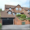
Detached houses
Ryecroft Rise, Lomé Ashton
Image: © Anthony O'Neil
Taken: 22 Jun 2020
0.14 miles
9
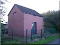
A little pink house
Actually an old electricity sub-station, dating from about the late 1920s.
Image: © Neil Owen
Taken: 2 Nov 2018
0.15 miles
10
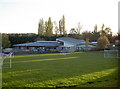
Northleaze Church of England Primary school
A modern and well-appointed school on the outskirts of Long Ashton.
Image: © Neil Owen
Taken: 2 Nov 2018
0.15 miles