IMAGES TAKEN NEAR TO
Keeds Lane, BRISTOL, BS41 9BY
Introduction
This page details the photographs taken nearby to Keeds Lane, BS41 9BY by members of the Geograph project.
The Geograph project started in 2005 with the aim of publishing, organising and preserving representative images for every square kilometre of Great Britain, Ireland and the Isle of Man.

There are currently over 7.5m images from over14,400 individuals and you can help contribute to the project by visiting https://www.geograph.org.uk
Image Map (Loading...)


Getting Data...Please wait
Leaflet Map data © OpenStreetMap
Images are licensed for reuse under creativecommons.org/licenses/by-sa/2.0
Notes
- Clicking on the map will re-center to the selected point.
- The higher the marker number, the further away the image location is from the centre of the postcode.
Image Listing (26 Images Found)
Images are licensed for reuse under creativecommons.org/licenses/by-sa/2.0
Image
Details
Distance
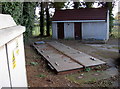
1
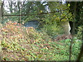
Reservoir on Keed's Lane
A rather old-fashioned round corrugated sheet type, lurking in among the vegetation.
Image: © Neil Owen
Taken: 15 Nov 2018
0.02 miles
2
To the Iron Plantation
The path above Long Ashton runs towards Providence Lane and the woodlands around it.
Image: © Neil Owen
Taken: 15 Nov 2018
0.02 miles
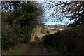
3
Keeds Lane climbing the escarpment north of Long Ashton
Image: © Tim Heaton
Taken: 9 Feb 2016
0.04 miles
5
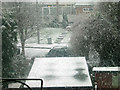
Lynbrook, Long Ashton
taken from our back bedroom window - our house is on Yeomeads
Image: © mac jordan
Taken: 26 Feb 2004
0.05 miles
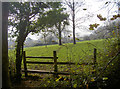
6
Monarch's Way below Keed's Wood (2)
The long distance footpath beside woods on the northern fringes of Long Ashton
Image: © Chris Heaton
Taken: 9 Feb 2016
0.05 miles
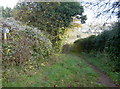
7
The edge of Keed's Wood
The footpath skirts in and out of the trees.
Image: © Neil Owen
Taken: 15 Nov 2018
0.07 miles
8
Monarch's Way below Keed's Wood (1)
The long distance footpath wending its way through woodland on the northern edge of Long Ashton
Image: © Chris Heaton
Taken: 9 Feb 2016
0.07 miles
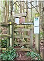
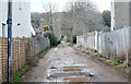
9
Half way up Keed's Lane
Walkers using the Monarch's Way path will happen across this post-war electricity substation.
Image: © Neil Owen
Taken: 15 Nov 2018
0.10 miles
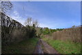
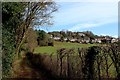
10
To the Woods
Keeds Lane, Long Ashton: follows 'The Monarch's Way' - a signed complex of paths stretching over 600 miles from Worcester to the South Coast.
It commemorates the route taken by the future Charles II escaping (disguised) from the final battle of the Civil War and in pursuit of safe passage to France. It was hoped a ship would be found at Bristol, so the Royal refugee stayed briefly at nearby Leigh Court, having travelled from Dundry northwards via Long Ashton. But no local vessel was bound for France, at the time, so the clandestine journey continued until one was eventually secured in Sussex.
Image: © Anthony O'Neil
Taken: 22 Feb 2021
0.10 miles