IMAGES TAKEN NEAR TO
Pilgrims Way, BRISTOL, BS40 8TX
Introduction
This page details the photographs taken nearby to Pilgrims Way, BS40 8TX by members of the Geograph project.
The Geograph project started in 2005 with the aim of publishing, organising and preserving representative images for every square kilometre of Great Britain, Ireland and the Isle of Man.

There are currently over 7.5m images from over14,400 individuals and you can help contribute to the project by visiting https://www.geograph.org.uk
Image Map (Loading...)


Getting Data...Please wait
Leaflet Map data © OpenStreetMap
Images are licensed for reuse under creativecommons.org/licenses/by-sa/2.0
Notes
- Clicking on the map will re-center to the selected point.
- The higher the marker number, the further away the image location is from the centre of the postcode.
Image Listing (161 Images Found)
Images are licensed for reuse under creativecommons.org/licenses/by-sa/2.0
Image
Details
Distance

2
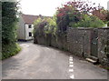
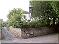
The Pilgrims Way
Wandering around the far side of Chew Stoke is Pilgrims Way, part of the older area of the village. Along it is a benchmark by the vertical pipe on the wall - see Image
Image: © Neil Owen
Taken: 5 Sep 2014
0.02 miles
3
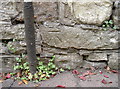
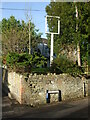
Pilgrims Way mark
A cutmark, as listed in the Benchmark Database: http://www.bench-marks.org.uk/bm60342 , on the wall of the old lane. The mark itself is not recorded until the twentieth century. See Image] for a wider view.
Image: © Neil Owen
Taken: 5 Sep 2014
0.02 miles
4
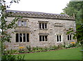
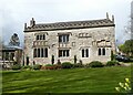
Wall of shields
The Old Rectory dates back to the early sixteenth century; then rector Sir John Barry built this fine rectory, which has had many alterations since, including the erection and subsequent removal of a clock tower. The south side features many shields and coats of arms: local landowners the St Loe family predominate, with other coats of the families of Fitzpane, Ancell, de la Rivere, and Malet. It is Grade II* listed.
Image: © Neil Owen
Taken: 5 Sep 2014
0.03 miles
5
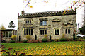
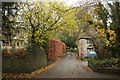
The Rectory, Chew Stoke
Grade II* listed "Built 1529 for Sir John Barry, Rector 1524-46" https://historicengland.org.uk/listing/the-list/list-entry/1320747 . "Coats of arms on front include 6 of-St. Lo family, alone or impaled with arms of Fitzpane, Ancell, de la Rivere and Malet." Viewed from the two Rivers Way following Church Lane.
Image: © Derek Harper
Taken: 25 Nov 2019
0.03 miles
7
The Yew Tree Inn
Chew Stoke's secluded pub has not enjoyed much fortune of late. The inn has become rather impecunious and looks a little run down now. The owners are drawing up plans to revitalise it but may need to offer guest house facilities or even convert to private use. This has caused a certain amount of protest from the villagers.
Image: © Neil Owen
Taken: 5 Sep 2014
0.03 miles
8
Can't see Yew
The old Yew Tree closed its doors in April 2013 after over a century of quenching thirsts.
Image: © Neil Owen
Taken: 1 Dec 2020
0.03 miles
9
Church Lane, Chew Stoke
On the left is a glimpse through trees of the grade II* listed Rectory https://historicengland.org.uk/listing/the-list/list-entry/1320747 , built in 1529.
Image: © Derek Harper
Taken: 25 Nov 2019
0.04 miles
10
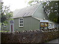
Nearly there
Chew Stoke village hall serves the villagers in many ways. It hosts the Parochial Church Council meetings, soup lunches, baby clinics, theatrical groups and is licensed for 100 guests. Currently it is close to reaching the appeal target for some repairs to its metal fabric.
Image: © Neil Owen
Taken: 5 Sep 2014
0.04 miles