IMAGES TAKEN NEAR TO
The Crescent, BRISTOL, BS40 8RH
Introduction
This page details the photographs taken nearby to The Crescent, BS40 8RH by members of the Geograph project.
The Geograph project started in 2005 with the aim of publishing, organising and preserving representative images for every square kilometre of Great Britain, Ireland and the Isle of Man.

There are currently over 7.5m images from over14,400 individuals and you can help contribute to the project by visiting https://www.geograph.org.uk
Image Map
Images are licensed for reuse under creativecommons.org/licenses/by-sa/2.0
Notes
- Clicking on the map will re-center to the selected point.
- The higher the marker number, the further away the image location is from the centre of the postcode.
Image Listing (121 Images Found)
Images are licensed for reuse under creativecommons.org/licenses/by-sa/2.0
Image
Details
Distance
1
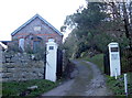
Fairfield Lodge
Built in 1879 it is part of the Fairfield estate and part of the footpath network in the area.
Image: © Neil Owen
Taken: 14 Dec 2018
0.01 miles
2
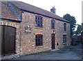
Dried wheat
The Wheatsheaf is another old pub that has closed its doors. Once one of the four originals in the village, it converted to private hands in 1963.
Image: © Neil Owen
Taken: 14 Dec 2018
0.02 miles
3
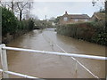
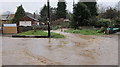
The Winford Brook suddenly rises up in Chew Magna
One of many flood scenes in Somerset today.
Image: © Dr Duncan Pepper
Taken: 12 Feb 2014
0.05 miles
4
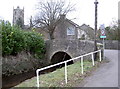
Bridge over the Chew
The road is a part of the National Cycle Route number 3.
Image: © Neil Owen
Taken: 16 Feb 2012
0.05 miles
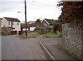
5

A tributary at The Batch
A small addition to the River Chew arrives from the reservoir, a little way west of the village.
Image: © Neil Owen
Taken: 14 Dec 2018
0.06 miles
6
Flash flooding in North Chew Terrace, Chew Magna
All this was caused by a small brook normally about a foot deep.
Image: © Dr Duncan Pepper
Taken: 21 Nov 2016
0.06 miles
7
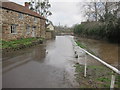
The Batch
Looking westwards, across a little bridge over the Chew. A benchmark can be seen on a wall nearby: Image
Image: © Neil Owen
Taken: 16 Feb 2012
0.06 miles
8
The Winford Brook overflows into The Batch- a back road in Chew Magna
Image: © Dr Duncan Pepper
Taken: 12 Feb 2014
0.06 miles
9
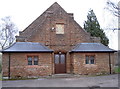
Church Hall
Chew Valley's hall, just across the way from the church itself. Built in 1923 with red stone typical of the area.
Image: © Neil Owen
Taken: 16 Feb 2012
0.07 miles
10
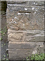
Benchmark on a wall
A cutmark, as described in the Benchmark Database: http://www.bench-marks.org.uk/bm41457 , on a wall in The Batch. See Image] for a contextual view.
Image: © Neil Owen
Taken: 16 Feb 2012
0.07 miles