IMAGES TAKEN NEAR TO
High Street, BRISTOL, BS40 7TQ
Introduction
This page details the photographs taken nearby to High Street, BS40 7TQ by members of the Geograph project.
The Geograph project started in 2005 with the aim of publishing, organising and preserving representative images for every square kilometre of Great Britain, Ireland and the Isle of Man.

There are currently over 7.5m images from over14,400 individuals and you can help contribute to the project by visiting https://www.geograph.org.uk
Image Map
Images are licensed for reuse under creativecommons.org/licenses/by-sa/2.0
Notes
- Clicking on the map will re-center to the selected point.
- The higher the marker number, the further away the image location is from the centre of the postcode.
Image Listing (141 Images Found)
Images are licensed for reuse under creativecommons.org/licenses/by-sa/2.0
Image
Details
Distance
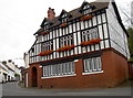
2
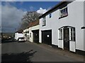
The old George Inn
The features of an inn remain although the panel has been painted over - a faint trace of the lettering can just be made out. Today it is George House and no longer pulls pints.
Image: © Neil Owen
Taken: 7 Aug 2017
0.02 miles
3
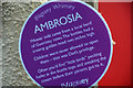
Blagdon : Ambrosia Sign
A sign about milk.
Image: © Lewis Clarke
Taken: 23 Jul 2020
0.02 miles
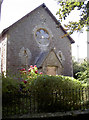
4
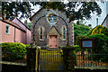
Blagdon : Baptist Church
Looking towards the Baptist Church.
Image: © Lewis Clarke
Taken: 23 Jul 2020
0.02 miles
5
Blagdon : Baptist Church
A Baptist Church.
Image: © Lewis Clarke
Taken: 23 Jul 2020
0.03 miles
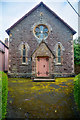
6
Blagdon Baptist church
The Baptist movement often found a welcome in villages and Blagdon was no exception. Originally, the members would meet in the Bell public house in Bell Square in the 1850s; requests were made to The Bristol Baptist Itinerant Society to send preachers to the village as the gathering grew. By the 1870s, funds had been secured to found this chapel. It opened in 1875 and was called ‘the Jubilee’ chapel to commemorate 50 years of the founding of The Bristol Baptist Itinerant Society.
Image: © Neil Owen
Taken: 15 Aug 2017
0.03 miles
7
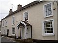
The Rent House
Blagdon, in common with many other villages, often expanded in an ad hoc way; the various styles and architectural facets are quite a mixture. This is The Rent House, a fine example.
Image: © Neil Owen
Taken: 7 Aug 2017
0.04 miles
8
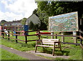
Blagdon play area
A well-equipped section for the kids, next to the recreation ground. See Image] for the mosaic.
Image: © Neil Owen
Taken: 15 Aug 2017
0.04 miles
9
Blagdon Community mosaic
Artist Wendy Phillips garnered the help of the residents to create this fine piece, which was unveiled on 6th September, 2015. See Image] for a wider view.
Image: © Neil Owen
Taken: 15 Aug 2017
0.04 miles
10
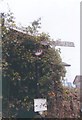
Direction Sign - Signpost on the A368 High Street in Blagdon
Pyramid finial - 2 arms; Somerset SCC pyramid and name by the A368, in parish of Blagdon (North Somerset District), on the west side of the T junction of Street End and the A368 High Street.
surveyed
Milestone Society National ID: SO_ST5058
Image: © J Dowding
Taken: Unknown
0.04 miles