IMAGES TAKEN NEAR TO
Nordrach Lane, BRISTOL, BS40 6LG
Introduction
This page details the photographs taken nearby to Nordrach Lane, BS40 6LG by members of the Geograph project.
The Geograph project started in 2005 with the aim of publishing, organising and preserving representative images for every square kilometre of Great Britain, Ireland and the Isle of Man.

There are currently over 7.5m images from over14,400 individuals and you can help contribute to the project by visiting https://www.geograph.org.uk
Image Map
Images are licensed for reuse under creativecommons.org/licenses/by-sa/2.0
Notes
- Clicking on the map will re-center to the selected point.
- The higher the marker number, the further away the image location is from the centre of the postcode.
Image Listing (4 Images Found)
Images are licensed for reuse under creativecommons.org/licenses/by-sa/2.0
Image
Details
Distance
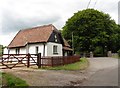
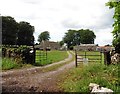
1
South of Ubley, Somerset
This road leads to Home Farm.
Image: © Stuart Buchan
Taken: 2 Apr 2006
0.13 miles
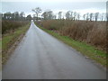
2
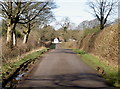
To Hazel Manor
The end of the road (a National Cycle Route) is marked by a large lodge, part of the Hazel Manor. The lodge is an entrance to a larger estate and there was once a gothic stile house here, but it was destroyed by fire in the 1930s. The land around here is now largely forested, although there was a concern in 2008 that the owners, charity Will Woodlands, were restricting access to ramblers.
Image: © Neil Owen
Taken: 18 Feb 2016
0.20 miles