IMAGES TAKEN NEAR TO
Bristol Road, BRISTOL, BS40 6HQ
Introduction
This page details the photographs taken nearby to Bristol Road, BS40 6HQ by members of the Geograph project.
The Geograph project started in 2005 with the aim of publishing, organising and preserving representative images for every square kilometre of Great Britain, Ireland and the Isle of Man.

There are currently over 7.5m images from over14,400 individuals and you can help contribute to the project by visiting https://www.geograph.org.uk
Image Map
Images are licensed for reuse under creativecommons.org/licenses/by-sa/2.0
Notes
- Clicking on the map will re-center to the selected point.
- The higher the marker number, the further away the image location is from the centre of the postcode.
Image Listing (10 Images Found)
Images are licensed for reuse under creativecommons.org/licenses/by-sa/2.0
Image
Details
Distance
1

Direction Sign - Signpost on the B3114 at White Cross Farm
Pyramid finial - 4 arms, 1 missing; Somerset SCC pyramid by the B3114, in parish of West Harptree (Bath And North East Somerset District), opposite White Cross Farm on the west side of the Y junction of the B3114 Bristol Road and the Old Bristol Road.
surveyed
Milestone Society National ID: SO_ST5557A
Image: © Milestone Society
Taken: Unknown
0.05 miles
2
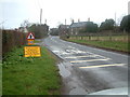
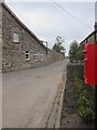
Compton Martin, Somerset
This road junction is close to White Cross Farm.
Image: © Stuart Buchan
Taken: 2 Apr 2006
0.07 miles
3
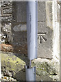
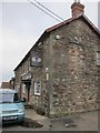
Blue Bowl benchmark
A cutmark in the southern corner of the Blue Bowl Inn, near Chew Valley Lake. See Image] for a location view and http://www.bench-marks.org.uk/bm47720 for the entry in the Benchmark Database.
Image: © Neil Owen
Taken: 18 Mar 2013
0.10 miles
4
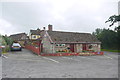
Blue Bowl Inn
This is the view of the rear of the public house from its own car park just off the B3114.
Image: © Nigel Mykura
Taken: 5 Aug 2015
0.11 miles
5
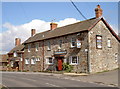
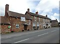
The Blue Bowl Inn
This country pub dates from the eighteenth century and its name refers to the local discovery of Roman coins and pottery (including fragments of a blue bowl). It lies on an old Roman road that runs to the right of shot - see Image It also has a benchmark in the corner nearest - see Image
Image: © Neil Owen
Taken: 18 Mar 2013
0.11 miles
7
The Blue Bowl Inn at West Harptree
Image: © Dr Duncan Pepper
Taken: 27 Mar 2014
0.12 miles
8
Stratford Lane or Lug Fal a former Roman Road
Image: © Dr Duncan Pepper
Taken: 27 Mar 2014
0.13 miles
9
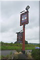
Pub Sign at the Blue Bowl
There are several pubs in the west country with this name and they frequently mention or show a picture of a bowl made of blue Bristol glass such as the one on this sign.
Image: © Nigel Mykura
Taken: 5 Aug 2015
0.14 miles
10
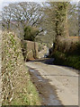
Not dead straight
Stratford Lane is an old Roman road; despite the modern interpretation not being totally in line, it is never the less part of a typically straight path across North Somerset. The road itself actually leads on to Chew Valley Lake, where it is submerged under the reservoir. However, the lake is twentieth century; before being flooded there was a Roman villa that it passed.
Image: © Neil Owen
Taken: 18 Mar 2013
0.20 miles