IMAGES TAKEN NEAR TO
Bath Road, BRISTOL, BS40 6HN
Introduction
This page details the photographs taken nearby to Bath Road, BS40 6HN by members of the Geograph project.
The Geograph project started in 2005 with the aim of publishing, organising and preserving representative images for every square kilometre of Great Britain, Ireland and the Isle of Man.

There are currently over 7.5m images from over14,400 individuals and you can help contribute to the project by visiting https://www.geograph.org.uk
Image Map
Images are licensed for reuse under creativecommons.org/licenses/by-sa/2.0
Notes
- Clicking on the map will re-center to the selected point.
- The higher the marker number, the further away the image location is from the centre of the postcode.
Image Listing (21 Images Found)
Images are licensed for reuse under creativecommons.org/licenses/by-sa/2.0
Image
Details
Distance
1
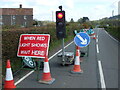
A halt before Herriott's Bridge
A short section of roadworks before the lake. The farm appears to be accepting some new pipes.
Image: © Neil Owen
Taken: 29 Apr 2021
0.02 miles
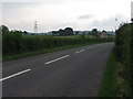
3
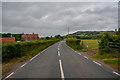
West Harptree : Bath Road A368
Looking along Bath Road.
Image: © Lewis Clarke
Taken: 29 Jun 2020
0.05 miles
4
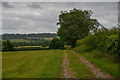
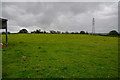
West Harptree : Grassy Field
A grassy field and track heading through it.
Image: © Lewis Clarke
Taken: 29 Jun 2020
0.06 miles
5
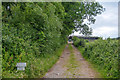
West Harptree : Track
A track heads up to Lower Gurney Farm.
Image: © Lewis Clarke
Taken: 29 Jun 2020
0.10 miles
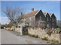
6
The A368 near Lower Gurney Farm
Moving away from Chew Valley Lake towards West Harptree.
Image: © HelenK
Taken: 3 Jun 2007
0.10 miles
7
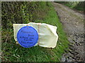
Guidance on Lower Gurney Farm
The home-made style of farm signage. The footpath comes up the lane and veers west across the fields beside it and the farm. However, this currently takes walkers into a field with cows and their new-born young - not the most sensible route. Instead, the farm allows users to stay on the lane and go through the farm buildings instead.
As it happened, a young farmer was there at the gate, beckoning the safer use of the lane.
Image: © Neil Owen
Taken: 29 Apr 2021
0.11 miles
8
West Harptree : Grassy Field
A grassy field in the countryside.
Image: © Lewis Clarke
Taken: 29 Jun 2020
0.11 miles
9
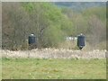
Strange towers near Herriott's Bridge Pool
Two dark, cylindrical structures peer over the reedbeds near the south end of Chew Lake. Are they bird hides? Are they part of the water infrastructure here? Or are they something to do with the former Herriott's (flour) Mill that stood very near here until the early 1900s?
Image: © Neil Owen
Taken: 29 Apr 2021
0.12 miles
10
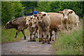
West Harptree : Track
A track with cows heading along it.
Image: © Lewis Clarke
Taken: 29 Jun 2020
0.13 miles